山とランニングの日記(旧ブログ goo)

山やランについてのブログです。メインサイトはhttp://asakaki.blogspot.jp/で毎日更新しています。

八ヶ岳 2006年4月 雪山練習

2006-04-05 22:00:00 | 積雪期登山
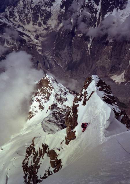
5月に穂高に登るためにまずは4月1日に八ヶ岳硫黄岳に登る
久しぶりに聞くアイゼンのきしむ音が気持ちいい

<object codebase="http://fpdownload.macromedia.com/pub/shockwave/cabs/flash/swflash.cab#version=8,0,22,0" width="320" height="240"><param name="movie" value="http://route.alpslab.jp/fslide.swf" /><param name="flashvars" value="routeid=cdfb8a4b2a99d6ba750d02f6d117cd26" /><embed src="http://route.alpslab.jp/fslide.swf" width="320" height="240" type="application/x-shockwave-flash" flashvars="routeid=cdfb8a4b2a99d6ba750d02f6d117cd26" /></object>

アルバム
http://photozou.jp/photo/list/63380/140496


大分出張でランニングしました

2006-04-02 21:45:00 | 出張ラン
2006年3月31日の大分出張でランニングしました城跡から川沿いをホバークラフトの乗り場まで走ります なぜかこの日はとても寒く、薄着しか持っていなかったのでとても寒い思いをしました ホテルの従業員の方に 大丈夫? と声をかけられてしまいました<EMBED src=http://route.alpslab.jp/fslide.swf width=320 height=240 type=application/x-shockwave-flash flashvars="routeid=6301a3420d7fddd77426da1cf3ea8c9b">

カラコルム遠征 1984年(学生時代M2)

2006-04-01 21:49:32 | 海外登山

学生時代にカラコルムの7000M峰サンゲマルマールを初登頂しました。
※Sangemar Marとは; Wikipedia, Google Map

アルバム(すべての写真をアップしています)
http://photozou.jp/photo/list/63380/142905
http://photozou.jp/photo/list/63380/142843
http://photozou.jp/photo/list/63380/142842
http://photozou.jp/photo/list/63380/142833
http://photozou.jp/photo/list/63380/140504


最終キャンプから見たSangemar Marのピーク

 
C3に向かう私            頂上へのアタック

 
C3(Ⅲ峰)への登り         C2 奥山ドクター


C2への登り

 
 松尾隊長


Webで探したその他関連記事
Himalayan Index(Sang-e-Marmarで完全一致検索)
Pakistan Travel Web
The glacier snout and Sangemar beyond

THE AMERICAN ALPINE JOURNAL 1985  CLIMBS AND EXPEDITIONS, 1984 331
Sangemar Mar. Our expedition succeeded in making the first ascent of Sangemar Mar by the southwest ridge. The members were Takashi Matsuo,leader, Dr. Hiromi Okuyama, Takehiko Hirota, Tokio Kozuki, Masaya Oishi, Toru Sakakibara, Kenya Sato, Shinichi Miyata, Tomoyoshi Mizukawa, Hiroyuki Onishi and me. Base Camp was in a pasture named Ilkish below the Muchichul Glacier at 4100 meters. Advance Base was at 4500 meters after a traverse to the foot of the southwest ridge. To reach Camp I at 5 100 meters we climbed 40” to 50” ice. There are two foresummits on the southwest ridge. Camp II at 5800 meters was at the foot of the first. We got to the top of this above an ice “slide” to place Camp III there at 6400 meters. On July 11 six members left Camp III, traversed around the second foresummit on the Batura side with fixed rope and reached the top (6949 meters, 22,800 feet) at two P.M. Two days later the remaining four members climbed to the summit. We fixed 3000 meters of rope in all.
AKIRA NOGUCHI, Osaka University, Japan 
(私の名前が間違っているToru→Atsushi)