


the Mt. Fuji crater come up 'to 4.2kilos from 'Fuji Yoshida city office to south.
12/02/2013 -- Yamanashi Nichinichi Shimbun ...
Sat., November 30, 2013 Yamanashi Nichinichi Shimbun
- It is the Mt. Fuji crater near the city area.
Fuji Yoshida-si and wild-goose hole Specialist "refuge area reexamination"
It turned out on the 29th that the trace that the Ministry of Land, Infrastructure, Transport and Tourism Fuji erosion control office blew off in "the wild-goose's hole " in the Fuji Kita exercise(Self Diffence Force) in the hall of Fuji Yoshida, and lava blew off by the eruption of Mt. Fuji was checked.
Shizuoka University [ which advised investigation of the office ] Professor Masato Koyama clarified on the same day in the study group on the theme of the volcanic disaster opened in Fuji Yoshida.
Although the wild-goose holewild-goose ノ hole is close to a city area in the about 2-km southwest in station Fuji Yoshida of a way, in the hazard map with which the eruption of Mt. Fuji was equipped, it is not assumed as area which can do a crater.
The call for reexamination of refuge area is going up as "the circumference of a wild-goose ノ hole becoming a crater in the case of an eruption" from a volcano specialist.
- Wild-goose hole (Fuji Yoshida) Huge cave http://www.fujisan-net.jp/GUNNAISPOT/spot-001.html which lava made
The "collapse hole" of the wild-goose ノ hole which stops the vestiges of the eruption of Mt. Fuji.
Those who visit although it is a hiking course are little = Kami-yoshida, Fuji Yoshida-shi. One corner of the pine wood in the Fuji Kita exercise place west side.
Two lava caves and 16 lava tree mould groups which are scattered all over about 4-ha commons are generically called "a wild-goose"
Although specified as the natural treasure of 1932 (Showa 7) years and a country, for the same year, the Mt. Fuji meteorological station started all year observation at the Mt. Fuji top.
"although the city is mentioning to one of the hiking courses, there are few people" at whom local drops in -- Mr. Koichi Kondo of a mountain-climbing guide.
As for a lava tree mould, a thing with many dugouts is the big feature.
Since there is also a hole of the nearly ten depth, when visiting, cautions are required for a scaffold.
A "collapse hole" is that in which the center of the lava cave (57 meters in length) crashed into, and the cave of both ends remained.
The collapsed portion (lava channel) has air colder than the circumference.
When it goes into a cave, the sunlight which a hole opens to the Amai part open and it inserts in it is dazzling.
A hole is called "trace that gas blew off at the time of an eruption" (Mr. Kondo).
Since it is in an exercise in the hall, the walk around a wild-goose ノ hole is restricted to an entry day.
Except local residents, the Iriyama application is required of a two Fuji Yoshida suburban village royal gift prefectural property protection association (Yoshida Onso).
Telephone 0555 (22) 3355.
■ Location 5605, wild-goose hole, Kami-yoshida, Fuji Yoshida-shi, Yamanashi-ken
November 08, 2013 Yamanashi Nichinichi Shimbun
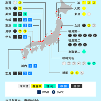
- Eruption of Mt. Fuji The first standard at a refuge appeal fallout in more than 30 cm 3 prefectures
Three prefectures in Yamanashi, Shizuoka, and Kanagawa which are working on broad-based disaster measures in preparation for the eruption of Mt. Fuji got the outline plan of the broader-based evacuation plan into shape by the 7th.
It classified into four disasters, such as a lava flow, a fallout and a mudflow, and the area for refuge and the standard of the refuge start were shown.
In addition to residents, the correspondence to the mountaineer and tourist by whom an increase is expected by Mt. Fuji having been registered into the World Cultural Heritage was also incorporated.
it comes out for the first time in the whole country to establish the refuge standard of a fallout by volcano disaster prevention, and it appeals for refuge in the area expected that 30 cm or more of volcanic asheses accumulate.
'富士吉田市市役所から南に 4.2kilos に富士山噴火口'
12/02/2013 … 山梨日日新聞...
2013年11月30日(土)山梨日日新聞
●市街地近くに富士山噴火口
富士吉田・雁ノ穴 専門家「避難エリア見直しを」
富士吉田市の北富士演習場内にある「雁ノ穴(がんのあな)」で、国土交通省富士砂防事務所が富士山噴火で溶岩が噴出した形跡を確認していたことが29日、分かった。同事務所の調査に助言した静岡大の小山真人教授が同日、富士吉田市内で開かれた火山災害をテーマにした研究会で明らかにした。雁ノ穴は道の駅富士吉田の約2キロ南西で市街地に近接しているが、富士山噴火に備えたハザードマップでは火口ができるエリアとして想定されていない。火山専門家からは「噴火の際は雁ノ穴周辺が火口になる可能性がある」として、避難エリアの見直しを求める声が上がっている。
・雁ノ穴 (富士吉田市) 溶岩が作った巨大洞穴
http://www.fujisan-net.jp/GUNNAISPOT/spot-001.html
富士山噴火の名残をとどめる雁ノ穴の「崩れ穴」。ハイキングコースだが、訪れる人は少ない=富士吉田市上吉田 北富士演習場西側にあるアカマツ林の一角。約4ヘクタールの入会地に散らばる、2つの溶岩洞穴と16カ所の溶岩樹型群を総称して「雁ノ穴(がんのあな)」と呼ぶ。1932(昭和7)年、国の天然記念物に指定されたが、同じ年には富士山頂で富士山測候所が通年観測を開始した。
「市がハイキングコースの1つに挙げているけど、地元でも立ち寄る人は少ないですよ」とは、登山ガイドの近藤光一さん。溶岩樹型は縦穴が多いのが大きな特徴。10メートル近い深さの穴もあるので、訪れる際には足場に注意が必要だ。
「崩れ穴」は、溶岩洞穴(長さ57メートル)の中央が崩落し、両端の洞穴が残ったもの。崩れた部分(溶岩溝)は、周囲よりも空気が冷たい。洞穴に入ると、天井部にぽっかりと穴が開き、差し込む陽光がまぶしい。穴は「噴火時にガスが噴出した痕跡」(近藤さん)という。
演習場内にあるため、雁ノ穴周辺の散策は立ち入り日に限られる。地元住民以外は、富士吉田市外二ケ村恩賜県有財産保護組合(吉田恩組)で入山申請が必要。電話0555(22)3355。
■所在地 山梨県富士吉田市上吉田字雁ノ穴5605
2013年11月08日山梨日日新聞
●富士山噴火 30センチ超で避難呼び掛け
降灰で初の基準 山静神3県
富士山噴火に備えて広域的な防災対策を検討している山梨、静岡、神奈川の3県は7日までに、広域避難計画の骨子案をまとめた。溶岩流や降灰、土石流など4災害に分類し、避難対象エリアや避難開始の目安を示した。住民に加え、富士山が世界文化遺産に登録されたことで増加が見込まれる、登山者や観光客への対応も盛り込んだ。火山防災で降灰の避難基準を設けるのは全国で初めてで、火山灰が30センチ以上積もると予想されるエリアで避難を呼び掛ける。


※コメント投稿者のブログIDはブログ作成者のみに通知されます