


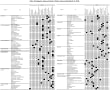
10月29日(金)~10月31日(日)、横浜の開港記念会館で開催された第12回日中韓国際ランドスケープ専門家会議・国際シンポジウムにて表題の研究論文(原文は英文)について、ポスター発表、学術研究会での研究発表を行いました。下表はスコットランドのHLAmapを作成しているRCAHMSとHistoric Scotlandによって確認されたすべての歴史的土地利用のカテゴリーとタイプと時期を筆者が一覧表としてとりまとめたものですが、これをみると18~19世紀以降の歴史的土地利用タイプの種類が多いことがわかります。この時期におけるイギリスの、大地への働きかけがいかに分厚いものだったかが推察されます。こうした過去の土地利用の形態的特徴が現在の土地利用やランドスケープの在りようを規定しているケースが多々見受けられます。
論文本体は Journal of Landscape Architecture in Asia Volume 5: New Challenges for Sustainable Landscape-Local wisdom and new strategy to live in a vernacular landscape-, October 2010, Japanese Institute for Landscape Architecture, Chinese Society of Landscape Architecture and Korean Institute of Landscape Architecture に所収されています。
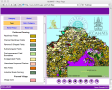
下図は歴史的土地利用タイプを表示したHLAmapの一例です。
HLAmapウェブサイトより。
以下、摘要のみ掲載させていただきます。
木下 剛* 芮 京禄**
*千葉大学大学院園芸学研究科、**国土技術政策総合研究所
摘要:本研究は、英国スコットランドの歴史的土地利用アセスメントに着目し、歴史的土地利用の概念とアセスメントの目的と方法について明らかにし、日本での応用可能性について考察することを目的に実施した。研究にあたっては、歴史的土地利用アセスメントの公式ウェブサイトを介して基礎情報の収集を行い、関連する書籍、行政資料その他の分析を行った。
その結果、1)景観そのものの歴史性に加えて、景観を支えている土地利用レベルの歴史性を措定することが可能であること。そのため、2)従来の歴史的環境評価、歴史的景観評価の対象とはならなかった地域においても新たな視点より歴史性を評価でき、新たな保全の在り方を見いだしうること。3)以上の手法は、歴史的景観や歴史的環境が失われている日本の市街地や郊外部において新たな歴史的環境評価及び保全の視点を提供しうること等を指摘した。
キーワード:歴史的土地利用アセスメント、歴史的景観、HLAマップ、スコットランド、イギリス
Meanings and the Method of Historic Land-use Assessment in Scotland
Takeshi KINOSHITA*, Kyungrock Ye**
* Graduate School of Horticulture, Chiba University
** National Institute for Land and Infrastructure Management
Abstract: The purpose of this study is to clarify the meanings of the term historic land-use and the method of assessment in the Historic Land-use Assessment in Scotland, UK, and to discuss on the possibility of its adaptation into Japan. To accomplish the research purpose, we collected basic information on the Historic Land-use Assessment official website, and analyzed the related books or administrative documents.
As a result, it was pointed out that 1) we can appoint the ‘historicalness’ at the level of land-use that support the landscape in addition to the historicalness of the landscape itself. For that reason, 2) we can find the historicalness and an ideal method of conservation from new point of view in the area where it is not done objectification by conventional method of historic environment evaluation or historic landscape evaluation. 3) The above-mentioned method will be able to offer new point of view for historic environmental evaluation and conservation in Japanese or eastern Asian towns and countries where a historic landscape and historic environment were lost.
Keywords: Historic Land-use Assessment, historic landscape, HLAmap, Scotland, United Kingdom
論文本体は Journal of Landscape Architecture in Asia Volume 5: New Challenges for Sustainable Landscape-Local wisdom and new strategy to live in a vernacular landscape-, October 2010, Japanese Institute for Landscape Architecture, Chinese Society of Landscape Architecture and Korean Institute of Landscape Architecture に所収されています。

下図は歴史的土地利用タイプを表示したHLAmapの一例です。
HLAmapウェブサイトより。

以下、摘要のみ掲載させていただきます。
木下 剛* 芮 京禄**
*千葉大学大学院園芸学研究科、**国土技術政策総合研究所
摘要:本研究は、英国スコットランドの歴史的土地利用アセスメントに着目し、歴史的土地利用の概念とアセスメントの目的と方法について明らかにし、日本での応用可能性について考察することを目的に実施した。研究にあたっては、歴史的土地利用アセスメントの公式ウェブサイトを介して基礎情報の収集を行い、関連する書籍、行政資料その他の分析を行った。
その結果、1)景観そのものの歴史性に加えて、景観を支えている土地利用レベルの歴史性を措定することが可能であること。そのため、2)従来の歴史的環境評価、歴史的景観評価の対象とはならなかった地域においても新たな視点より歴史性を評価でき、新たな保全の在り方を見いだしうること。3)以上の手法は、歴史的景観や歴史的環境が失われている日本の市街地や郊外部において新たな歴史的環境評価及び保全の視点を提供しうること等を指摘した。
キーワード:歴史的土地利用アセスメント、歴史的景観、HLAマップ、スコットランド、イギリス
Meanings and the Method of Historic Land-use Assessment in Scotland
Takeshi KINOSHITA*, Kyungrock Ye**
* Graduate School of Horticulture, Chiba University
** National Institute for Land and Infrastructure Management
Abstract: The purpose of this study is to clarify the meanings of the term historic land-use and the method of assessment in the Historic Land-use Assessment in Scotland, UK, and to discuss on the possibility of its adaptation into Japan. To accomplish the research purpose, we collected basic information on the Historic Land-use Assessment official website, and analyzed the related books or administrative documents.
As a result, it was pointed out that 1) we can appoint the ‘historicalness’ at the level of land-use that support the landscape in addition to the historicalness of the landscape itself. For that reason, 2) we can find the historicalness and an ideal method of conservation from new point of view in the area where it is not done objectification by conventional method of historic environment evaluation or historic landscape evaluation. 3) The above-mentioned method will be able to offer new point of view for historic environmental evaluation and conservation in Japanese or eastern Asian towns and countries where a historic landscape and historic environment were lost.
Keywords: Historic Land-use Assessment, historic landscape, HLAmap, Scotland, United Kingdom

※コメント投稿者のブログIDはブログ作成者のみに通知されます