goo blog サービス終了のお知らせ 

くっしーの徒然日記

無線、天文、修理、剣道、体調他について書いてます。修理や改造記事のマネに関してはあくまでも自己責任にてお願いします。

蔵王/熊野岳 JA/YM-004 SOTA運用

2023-10-05 | アマチュア無線
帰省ついでの東北旅行も最終日8/13日の日曜日。昨日雨であきらめた蔵王/熊野岳1,841mJA/YM-004に再挑戦する事にした。
The last day of my trip to Tohoku while returning home was Sunday, August 13th. I decided to try again on Zao/Kumanodake 1,841mJA/YM-004, which I had given up on due to the rain yesterday.

↓蔵王で有名な「お釜」

↑Famous "Okama" in Zao

↓車でエコーラインの終点、刈田岳のふもとまで行く。遠くに見えるのは熊野岳辺り。

↑Go to the end of the Echo Line at the foot of Mt. Karitadake. Kumanodake is in the distance.

↓SOTAポイントは直ぐ上の刈田岳ではなく、熊野岳なので、そちらを目指して山歩き。

↑The SOTA point is not Karitadake, but Kumanodake, so hiked towards that.
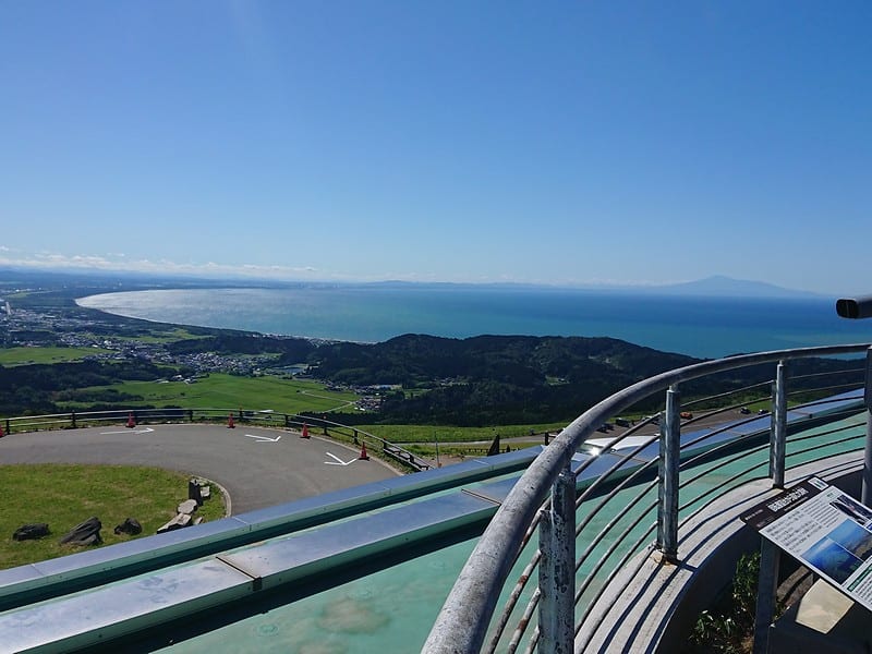
↓東の空は雲海になっている。

↑The eastern sky is a sea of clouds.

↓雲海と「お釜」(ちょっと水滴か何かが反射しているのはご愛敬)

↑Sea of clouds and “Okama”

↓右に行くと避難小屋経由、左に行くと熊野岳山頂ダイレクト。

↑The right is via the evacuation hut, and the left is directly to the summit of Mt. Kumanodake.

↓熊野岳直通の左のルートを進む。

↑Take the left route that leads directly to Kumanodake.

↓山頂の神社が見えてきた。

↑The shrine at the top of the mountain came into view.

↓山頂の神社と鳥居と緑屋根は避難小屋?

↑The shrine and torii gate at summit, and are green roof may be shelter?

↓少し離れて山頂の標識。

↑The sign for the summit.

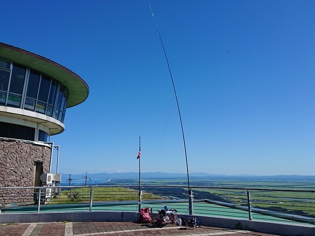
↓一通り見て回って、少し戻った所にアンテナを設営

↑After looking around, set up the antenna a little further back.

先ずは21MHzからCQ。北米、台湾からコールされた。
First of all, CQ from 21MHz. Called from North America and Taiwan.

18MHzはDXは飛んでないが、EsかGWなのか、長野ローカル局に呼ばれた。
DX is not open at 18MHz, but called from a Nagano local station, is it Es or GW?

14MHzも韓国からのコールと弱いEsかGWか判らないが関東局からも呼ばれた。
14MHz was also called by Korea and the Kanto station.

7MHzにQSYすると、国内が良く開けており、1,2,3,4,7,9,0と沢山呼ばれた。
QSY to 7MHz, the JA was opened and I called from the 1,2,3,4,7,9,0 area.

↓偶然、山岳ガイドでアクティベータのILX/デビットさんとアイボール。

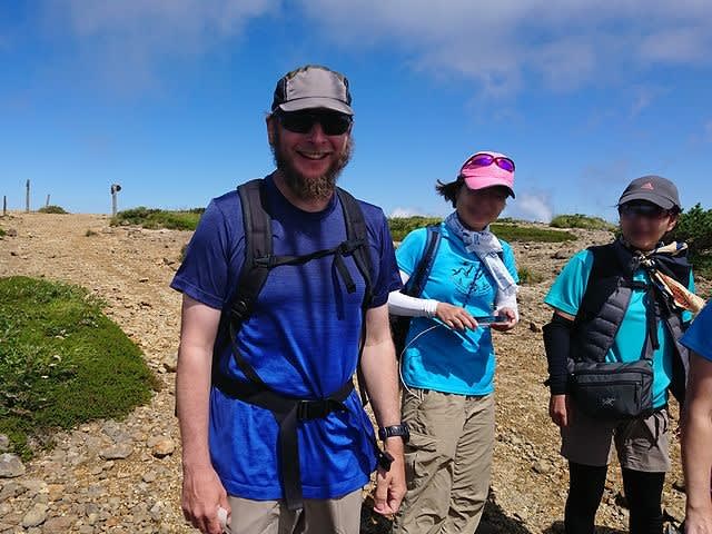
↑I happened to meet ILX/David-san, who is a mountain guide and Activator.

この日はKX2で運用。デビットさん所で買った(tr)uSDXを持って来てれば良かった。
On this day, I operated by KX2. I should have brought the (tr)uSDX I bought from David-san.

XYLの方は、福島、仙台、山形市とも近いので、V/UのSSBで9-QSO。
About XYL, here is close to Fukushima, Sendai, and Yamagata City, so 9-QSOs at V/U SSB.

神栖のカモさんとも430でQSO。
And QSO with Kamo-san from Kamisu-city Chiba pref. on 430.

一通り終えて撤収して下山する。
With that, we withdrew and headed down the mountain.

↓下山途中では、お釜の辺りは少しガスってきていた。

↑On the way down the mountain, there was a bit of gas around the pot.

お釜を過ぎると又晴れていた。
When I passed Okama, it was sunny again.

↓無事に駐車場到着。

↑Arrived at the parking lot.

今日は一日良い天気で眺めも良く、雲海と「お釜」もきれいに見れて良かった。
It was a nice day today, and the view was good, and I was able to see the sea of clouds and Okama clearly.

本日の結果 Today's result

21MHz/CW 4-QSO BV=1 W=2 included
18MHz/CW 1-QSO
14MHz/CW 3-QSO HL=1 included
7MHz/CW 31-QSO S2S(JA)=3 included

合計 Total 39-QSO

本日もお相手頂いたor追いかけて頂いた各局様有難うございました。
TNX for all stations who QSO with me or searching for me!

2023.8.13 (10/05 UP)

蔵王・山形城址と高つむじ山 JA/YM-078

2023-10-02 | アマチュア無線
8月12日土曜日は、先ずは蔵王山へSOTA運用に出かけたが、雨で中止。仕方なくお城観光と、車で上がれる南陽市の高つむじ山での運用に切り替えた。
On Saturday, August 12th, we first went to Mt. Zao for SOTA activation, but it was canceled due to heavy rain. I switched to castle sightseeing and SOTA activations at other mountains that I could drive up.

↓高つむじ山JA/YM-078での運用風景

↑Operation scene at Takatsumujiyama JA/YM-078

朝起きて小雨だったが、一応蔵王迄行ってみる事にした。
It was raining when I woke up in the morning, but I decided towent to Zao.

エコーラインの終点の駐車場迄行ってみたが、結構強い雨が降っている。
I went to the parking lot at the end of the Echo Line, but heavy raining.

お釜が見えるかもと駐車場のすぐ上の刈田岳山頂まで行ってみる。
I went to the summit of Mt. Karitadake just above the parking lot to see if I could see the 「Okama」.

↓刈田岳山頂から見た、雨の中の蔵王のお釜。

↑「Okama」 of Zao in the rain seen from the summit of Mt. Karitadake.

雨の中、お釜は見えるが、雨も強いので、熊野岳での無線運用はあきらめる。
I can see the「Okama」in the rain, but strong rain so I give up to activate at Mt. Kumanodake.

山形市内まで戻って、山形城址公園に行くことにする。
Return to Yamagata City and go to Yamagata Castle Ruins Park.

↓山形城址公園 本丸一文字門とお堀

↑Yamagata Castle Ruins Park Honmaru Ichimonji Gate and moat

↓城内にある山形市郷土館(お城印がここにある)

↑Yamagata City Local Museum in the park (the castle stamp is here)

お城印をゲットして、次の本庄市に行く途中でJA/YM-078高つむじ山693mへ。
Get a castle stamp and head to JA/YM-078 Takatsumujiyama 693m on the way to Honjo City.

ここは一応車で頂上まで行けるとの事前情報。途中から未舗装林道になり、いくらか荒れている所は有る物の長野の月蔵山や立山、先週登った音見山の林道に比べると全然問題ないレベルで登れる道だった。
The trail turns into an unpaved forest road, and there are some rough spots. However, compared to the forest roads of Mt. Gatsuzousan, Mt. Tateyama in Nagano, and Mt. Otomiyama that I climbed last week, it was an easy path to drive up.

↓無事に高つむじ山山頂到着。先端にグライダー用のスロープが有る。

↑Arrival at the mountaintop. There is a slope for gliders at the tip.

↓山頂から見た景色。

↑The view from the top of the mountain.

山頂には、単管で組んだ屋根のあるスペースが有るのでそこに機材を展開。
At the top, there is a shack made of iron pipes, so we deployed radio there.

↓無線機をセット

↑Prepare the radio

21MHzからCQ開始。
Start CQ from 21MHz.

しかし、台湾と北海道から呼ばれたのみ。
However, only called from Taiwan and Hokkaido.

18MHzにQSYするが、誰にも呼ばれない。
I QSY to 18MHz, but no one called.

14MHzにQSYすると、かろうじてJA局と2-QSO。
QSY to 14MHz, only 2-QSO with JA station.

↓アンテナの様子

↑Today's antenna

最後に7MHzでCQを出すが、今日は余り呼ばれず、9-QSO。
CQ on 7MHz, but I don't get many calls today, so only 9-QSOs.

XYLは2mと430のFMで何とか5-QSO。
XYL was 5-QSOs on 2m and 430 FM.

大きな町が近くにない山では、V/UのSSBは応答が無い様だ。
In the summit where there are no large towns nearby, V/U SSB is no response.

↓この日はずっと雨の中での運用となった。

↑On this day, the operation was carried out in the rain.

今日は雨で蔵王に登れなかったので残念だった。
It was a pity that I couldn't climb Zao today because of the rain.

また、無線の方もDXは台湾1局、国内ももう一つで、ちょっと寂しい結果。
Also the radio, DX was only 1, and the CONDX in JA were bad, so there are few QSOs..

明日晴れたら、蔵王に再挑戦だな。
If it's sunny tomorrow, I'll try Zao again.

本日の結果 Today's result

21MHz/CW 2-QSO BV=1 included
18MHz/CW 0-QSO
14MHz/CW 2-QSO 
7MHz/CW 9-QSO S2S(JA)=2 included

合計 Total 13-QSO

本日もお相手頂いたor追いかけて頂いた各局様有難うございました。
TNX for all stations who QSO with me or searching for me!

2023.8.12 (10/02 UP)

寒風山 JA/AT-135 SOTA運用

2023-09-26 | アマチュア無線
夏休みの8月11日に秋田に行ったついでに、男鹿市にある寒風山355mへSOTA運用に出かけた。
While I went to Akita on August 11th during summer vacation, I went to Mt. Kanpuzan 355m in Oga City for SOTA activation.

↓途中道沿いに巨大なまはげの像

↑A huge Namahage statue on the way

↓寒風山山頂。直ぐ下まで車で来られる。

↑Kanpuzan summit. You can come nearby by car.

↓さっそく無線機の準備

↑Preparing the radio

今日は21MHzからスタート。北米、台湾、国内と呼ばれる。
Today started at 21MHz. Called from North America, Taiwan, and JA.

国内Esが出ている様だ。
Domestic Es seems to be open.

18MHzでも、北米、韓国、国内と呼ばれた。
18MHz, also called North America, South Korea, and JA.

↓本日のアンテナとシャック

↑Today's antenna and shack

14MHzでは、韓国と国内は関東圏から呼ばれた。
At 14MHz, Korea and JAs(mainly from the Kanto area) were called .

最後に7MHzに降りて国内チェイサー各局とQSOして撤収。
QSY to 7MHz, QSO with a domestic chasers, and withdrew.

XYLの方は、2mで4-QSOを何とかクリア。
For XYL, clear 4-QSO at 2m.

↓男鹿湾の右手遠くに鳥海山が見える

↑Mount Chokai can be seen in the distance on the right side of Oga Bay

9時を過ぎるとかなり暑くなって来たので、早々に撤収した。
It got really hot after 9 o'clock, so we withdrew early.

と言う事で、本日は義実家での空き時間でのSOTA運用だった。
So, today I did SOTA activation in my free time before event.

本日の結果 Today's result

21MHz/CW 4-QSO NA=1 BV=1 included
18MHz/CW 4-QSO NA=1 HL=1 included
14MHz/CW 6-QSO HL=1 included
7MHz/CW 11-QSO S2S(JA)=2 included

合計 Total 25-QSO

本日もお相手頂いたor追いかけて頂いた各局様有難うございました。
TNX for all stations who QSO with me or searching for me!

2023.8.11 (9/26 UP)

音見山 JA/NN-120 SOTA運用

2023-08-03 | アマチュア無線
7月30日の日曜日に、伊那市にある音見山1,528mへSOTA運用に出かけた。
On Sunday, July 30th, we went to Otomiyama 1,528m in Ina City for SOTA activation.

↓音見山 山頂

↑Otomiyama summit

ここは、登山口のだいぶ手前からダートの林道を数km程走らないと行けない。
Here, we have to drive a few kilometers on a dirt forest road to the trailhead.

途中のダートが水たまりでぬかるんでいたり、水が流れた後で大きくえぐれていたりとかなり荒れている道を進む事になり、思ったより時間がかかる。
The dirt on the way was muddy with puddles, and after the water flowed, the road was quite rough, so it took longer than I expected.

↓最後は右から少し山側が崩れてきて道幅が狭くなっている。

↑Finally, the mountain side collapsed and the width of the road narrowed.

諦めて、少し手前に車を置いて、ダートの林道を歩く。
I gave up, put the car a little before, and walked the dirt forest road.

↓草ぼうぼうの所も有る。

↑There is also a lot of grass on the road.

↓林道の途中にへびイチゴ。

↑Snake strawberry on the forest road.

↓1km強歩いて、尾根筋の低くなってる所にとりつく。

↑Walk over 1km and enter the ridge from where the ridge is low.

↓尾根筋には鉄塔の保守用道路と思われる道が続いている。

↑A road is for maintenance of the tower.

思っていたより登りが多く、休み休み登る。
There were more climbs than I expected, so I took a break and climbed.

↓なんとか林道の町境辺りからくる道との分岐点迄たどり着いた。

↑I arrived at the junction with the road coming from around the town boundary.

ちなみに、林道の町境からくる道は、ヤブが深く獣臭がするのでパスしている。
By the way, I skipped the forest road from the town boundary because the thickets smelled like beasts.

↓分岐から南方向に曲がる。倒木が少し邪魔している。

↑Turn south at the fork. A fallen tree is a little in the way.

↓ここから右に曲がって少しで山頂だ。

↑Turn right from here and the summit is a little further.

↓山頂の三角点に到着。

↑Arrive at the triangulation point of the summit.

ここは山頂の眺望は無いが、その分林の中で、下界の酷暑が噓の様に涼しい。
There is no view from the summit, but it is cool in the forest.

少し寒いぐらいだ。
It's a little cold.

↓さっそく無線機の準備

↑Preparing the radio

先ずは21MHzからCQ。
CQ from 21MHz.

今日はコンディションが悪いみたいで、国内局1局しか呼ばれない。
The conditions are bad today, and only one JA station is called.

なんとなく、ハイバンドはダメそうなので、先に7MHzでCQ。
The condition of the high band seems to be bad, so CQ at 7MHz first.

こちらは何とか国内各局から呼ばれた。
This was called by various domestic stations.

その後、再びハイバンド、18MHzでCQ。
Then high band again, CQ at 18MHz.

これまた、近くの局1局のみ。
Again, only one nearby station.

↓本日のアンテナ

↑Today's antenna

14MHzにQSYするも、北海道に行ってるWMNさんからのコールのみ。
QSY to 14MHz, but only calls from WMN-san who is in Hokkaido.

今日はハイバンドのコンディションほんとに悪いなぁ。
The high band DX conditions are really bad today.

もっと上に上がればオセアニアに開けてないかと、24MHzでCQ。
CQ at 24MHz, wondering if Oceania could be open if it went higher.

これまた、東北と北海道のWMN局のみ。
Again, only WMN-san in Hokkaido and Tohoku station.

28MHzも試してみるが、こちらも北海道のWMNさんのコールのみ。
I'll try 28MHz, but only calls from WMN-san in Hokkaido.

全くもって今日はDXが開けていない。ちょっと時間が遅かったかなぁ?
DX is not open today at all. Was it a little late?

XのV/Uは今日はS2Sが多く、既に8-QSO。
XYL's V/U is mostly S2S today, already 8-QSO.

↓と言う事で一通り運用を終え、お昼ご飯にする。

↑ Almost finished the operation and had lunch.

↓お昼ご飯の後は、XのCW練習で、7MHzにでる。

↑After lunch, XYL operats on 7MHz for CW practice.

7MHzもコンディションが落ちた様で、TWやSW3に載せてもやっと4-QSO。
7MHz also fell in condition. 4-QSOs even if SPOT to SW3 or TW.

↓と言う事でお昼過ぎに荷物を片付けて下山開始。

↑So I put my luggage away in the early afternoon and started descending.

↓無事に車まで帰着。

↑Return to the car.

↓本日のルート

↑Today's route

今日は林道歩きが結構長かったが、全体的に林の中を歩いているのでそれ程暑くなくて助かった。でも途中の林道がかなり荒れてるから、もう次は来ないかなぁ、、、、
It was quite a long walk through the forest today, but I was glad that it wasn't so hot because I was walking mostly in the forest. But the forest road on the way is pretty rough, so I wonder if I won't come next time...

本日の結果 Today's result

21MHz/CW 1-QSO
7MHz/CW 19-QSO S2S(JA)=4 included
18MHz/CW 1-QSO
14MHz/CW 1-QSO
24MHz/CW 2-QSO S2S(JA)=1 included
28MHz/CW 2-QSO
144MHz/SSB 1-QSO S2S(JA)=1
430MHz/FM 5-QSO S2S(JA)=5

合計 Total 32-QSO

本日もお相手頂いたor追いかけて頂いた各局様有難うございました。
TNX for all stations who QSO with me or searching for me!

2023.7.30 (8/2 UP)

東篭ノ塔山 JA/NN-051 SOTA運用

2023-07-19 | アマチュア無線
祝日の月曜日に東篭ノ塔山2,228m JA/NN-051へSOTA運用に出かけた。ここは途中の道のゲートオープンが、6時半頃なので、湯ノ丸高原の駐車場で靴を履き替えたり登山準備をしてゲート前で係員が来るのを待った。
I went to Mt. Higashi Kagono Toyama 2,228m JA/NN-051 for SOTA activation on Monday, which is a holiday. The gate on the way here opens around 6:30, so I changed my shoes at the Yunomaru Kogen parking lot, prepared for climbing, and waited for the attendant to come in front of the gate.

↓係員到着。ゲートを開けて貰う所。

↑A staff member arrived. opened the gate.

↓6:40頃登山開始。なだらかなUp/Downの木陰を進む。

↑Started climbing around 6:40. Proceed through the gentle Up/Down shade.

↓だんだん登りがきつくなる。木の根っこが一杯出てる。

↑The climb gets harder and harder. A lot of tree roots are sticking out.

↓途中で見晴らしの良い所に出た。遠くに富士山が見える。

↑ On the way, I came to a place with a good view. Fuji can be seen in the distance.

↓もう少しで山頂か?ゴロゴロの岩場を登る。

↑Is it almost the summit? Climb rugged rocks.

↓山頂の標識が見えた。奥の看板が山頂だ。

↑I saw the sign for the summit. The sign in the back is the summit.

↓山頂到着。右後ろ手前は水ノ塔山。

↑Arrive at the summit. Mt. Mizunota is in front of the right back.

↓さっそく無線機を準備。

↑ Prepare the radio.

21MHzからCQ。ニュージーと台湾からのコールがあった。
CQ from 21MHz. There were calls from New Zealand and Taiwan.

18MHzに降りる。ここでは北米と台湾からコール。
Down to 18MHz. Call here from North America and Taiwan.

14MHzでのCQはさっぱり呼ばれなかった。
CQ at 14MHz was never called.

↓アンテナを含めた運用風景。

↑Operation scenery including the antenna.

珍しく、10MHzで運用。韓国と国内各局からのコールがあった。
Unusually, it operates at 10MHz. There were calls from Korea and domestic stations.

7MHzでCQ。あまりCONDXは良くない。国内から少しだけ呼ばれた。
CQ at 7MHz. CONDX is not so good. I was called a little from the country.

↓一通り終わったので、ちょっと早いけどお昼ご飯。

↑It's a little early, but it's time for lunch.

今日はいい天気で日なたでの運用は暑い。
It's nice weather today and it's hot to operate in the sun.

↓10時過ぎになると、北から雲がもくもく出てきた。

↑After 10 o'clock, clouds came out from the north.

でも日陰にはほとんどならず、相変わらず暑い。
But it's still hot and there's hardly any shade.

↓北の空はこんな感じ。雨が降らないかちょっと心配。

↑The northern sky looks like this. I'm a little worried if it will rain.

ここはいつも真上位まで雲が来ることが多い。
Clouds often come right up to the top here.

積乱雲を気にしながら、S2SといくつかQSO。
Some S2S-QSOs while worrying about the cumulonimbus.

そろそろ撤収かな。
Will it be withdrawn soon?

↓いざ撤収を始めると、SPOTが上がるので、またリグを出す。

↑When I start withdrawing, the SPOT would up, so I put out the rig again.

2度ほど片付けたり出したりしていると、アラートの最後のAJXさんが出て来た。
When I put it away and took it out twice, the last alert, AJX-san came out.

でも28MHzは無理!と思いつつ聞きに行くと、相手のVK5CZ、Ianさんが聞こえた。
But 28MHz is impossible! When I listened, I could hear VK5CZ/Mr. Ian.

28MHzはオーストラリアが開けているのか!!今日は未交信だ!
Is 28MHz open for Australia? ! No QSO with Australia today!

FBでメッセージを送って、1KHz上でオーストラリアのIanさんとQSO。
I sent a FB message and QSO with Mr. Ian from Australia UP 1KHz.

そうこうして居る内に、AJXさんも24MHzに降りてきて、かすかに聞こえる。
In the meantime, AJX-san down to 24MHz. Weak signal but audible.

AJXさんと最後のS2S-QSOをゲットして、心置きなく撤収・下山開始。
After getting the S2S-QSO with AJX-san, I withdrew and descending.

下りは、岩場とか段差が比較的大きいので、膝の負担を考えてゆっくり下る。
On the descent, there are places with large steps, so I cover my knees and go down slowly.

↓車まで下山完了。今日は登り54分下り56分と下りに時間がかかった。

↑Go down to the car. Today it took 54 minutes to climb and 56 minutes to go down.

下りの時間帯はかなり暑かったので、10分おきに水分補給しながらだったからかも。
Today very hot during the descent. Maybe it was because I was drinking water every 10 minutes.

なんだかんだ、かなり暑かったので、飲み物1Lではギリギリだった。
It was quite hot, so 1L of drink was barely enough.

この時期はもう少し持って行った方が安全だなぁ。
It's safer to bring a little more at this time of year.

本日の結果 Today's result

21MHz/CW 7-QSO S2S(JA)=1 ZL=1 BV=1 included
18MHz/CW 5-QSO S2S(JA)=1 W=2 BV=1 included
14MHz/CW 2-QSO S2S(JA)=2
10MHz/CW 8-QSO S2S(JA)=3 HL=1
7MHz/CW 6-QSO S2S(JA)=1 included
28MHz/CW 1-QSO VK=1
24MHz/CW 1-QSO S2S(JA)=1
430MHz/FM 5-QSO S2S(JA)=5

合計 Total 35-QSO

本日もお相手頂いたor追いかけて頂いた各局様有難うございました。
TNX for all stations who QSO with me or searching for me!

2023.7.17 (7/19 UP)