釣りさせてよ!
https://tenki.jp/past/2021/08/10/satellite/
九州豪雨鵜2021年8月10日より「線状降水帯」の起源 仮説 人災?
九州豪雨鵜2021年8月11日より「線状降水帯」気象庁の新語
首相官邸ホームページ

2021年8月11日からの大雨の災害

↑の場所だけみて 人工的に雲が作られている?
{線状に雲の種が数時間打ち上げられている」視線にできるはずがない。
☆夜明けからお昼12時まで 規則的に時間と場所固定の線状雲
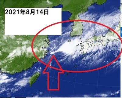
上海沿岸から 線状降水帯 の雲が発生している!
上記写真を8月10日から順番に記載。
自分で考えて!
時系列でみる
台風が8月9日台風くるも 無視
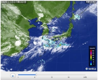
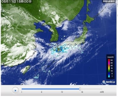
☆8月10日の朝から線状降水帯は、中国上海沿岸から始まっていた 人為的な災害か?仮説
クリックすると、衛星画像動画見られます 上海沖に朝6時から急に日本全体より大きい雲が6時間でできるのは、人工降雨剤をまかないと、できる雲じゃない。日本の気候を上海沖の雲発生実験で、かえられた、線状降水帯は、人為的。 官邸ホームページは、わかっていて、災害復旧費をみつもってたか? 準備が過去にされていた? うそだろ
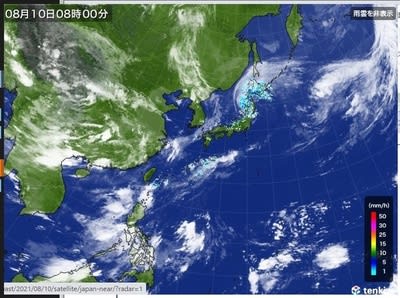
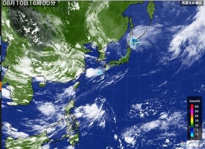
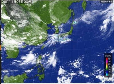
8月10日より衛星画像
8月10日

8月10日中国上海沿岸日雲
8月10日沖縄に巨大円形雲発生
8月11日朝 九州長崎差がに50年に一度の雨


だれか、教えて?
8月10日からはじまった、九州豪雨
There is a fixed time to spread the artificial rain agent.
A small dot occurs at dawn time.
that is. After 3 hours, the clouds become linear.
that is. Clouds rapidly became huge around 12 o'clock. It will be 1000 km long
It forms a circular cloud with a diameter of 200 km after 5 hours.
It reaches the land. It is a 20m rise. The rise makes it rain.
It becomes a cumulonimbus cloud when it rises 100m. Lightning creates an updraft.
Artificial rain agents are heavy, slow, and have a personality that stays.
It kept raining in the same spot, and features were added.
Automatic translation
Artificial rainfall agents have been tested in Japan.
It has the potential to be used worldwide and in the mainland of the United States. It may discourage growing grains.
https://tenki.jp/past/2021/08/10/satellite/
九州豪雨鵜2021年8月10日より「線状降水帯」の起源 仮説 人災?
九州豪雨鵜2021年8月11日より「線状降水帯」気象庁の新語
首相官邸ホームページ
2021年8月11日からの大雨の災害
↑の場所だけみて 人工的に雲が作られている?
{線状に雲の種が数時間打ち上げられている」視線にできるはずがない。
☆夜明けからお昼12時まで 規則的に時間と場所固定の線状雲
上海沿岸から 線状降水帯 の雲が発生している!
上記写真を8月10日から順番に記載。
自分で考えて!
時系列でみる
台風が8月9日台風くるも 無視
☆8月10日の朝から線状降水帯は、中国上海沿岸から始まっていた 人為的な災害か?仮説
クリックすると、衛星画像動画見られます 上海沖に朝6時から急に日本全体より大きい雲が6時間でできるのは、人工降雨剤をまかないと、できる雲じゃない。日本の気候を上海沖の雲発生実験で、かえられた、線状降水帯は、人為的。 官邸ホームページは、わかっていて、災害復旧費をみつもってたか? 準備が過去にされていた? うそだろ
8月10日より衛星画像
8月10日
8月10日中国上海沿岸日雲
8月10日沖縄に巨大円形雲発生
8月11日朝 九州長崎差がに50年に一度の雨
だれか、教えて?
8月10日からはじまった、九州豪雨
There is a fixed time to spread the artificial rain agent.
A small dot occurs at dawn time.
that is. After 3 hours, the clouds become linear.
that is. Clouds rapidly became huge around 12 o'clock. It will be 1000 km long
It forms a circular cloud with a diameter of 200 km after 5 hours.
It reaches the land. It is a 20m rise. The rise makes it rain.
It becomes a cumulonimbus cloud when it rises 100m. Lightning creates an updraft.
Artificial rain agents are heavy, slow, and have a personality that stays.
It kept raining in the same spot, and features were added.
Automatic translation
Artificial rainfall agents have been tested in Japan.
It has the potential to be used worldwide and in the mainland of the United States. It may discourage growing grains.