goo blog サービス終了のお知らせ 

三木奎吾の住宅探訪記

北海道の住宅メディア人が住まいの過去・現在・未来を探索します。

【年末進行の忙中閑、潔く荒涼たる自然の癒し】

2022-12-16 06:32:17 | 日記


根を詰めての慎重作業に掛かりきりの状況が続いています。
神経疲労系の状況ですが、ちょっと一段落したので
所用のついでにクルマで足をすこし伸ばしてみた。
札幌近郊、石狩浜のきのうの様子です。

どうという変化に乏しい自然景観が目に入ってくる。
石狩川河口のラグーンだけれど川が大きいので
その面積はそれなりの広がりがある。
幼年期・少年期から親しんできた北海道的な初冬の情景。
徐々に寒気が深まってきてわずかの積雪も容易に融けない。
テカテカの路面になってクルマの制動に注意しながら運転する。
裸になった木々がやや強い風に揺られている。
そのゆらぎから伝わってくる独特の季節感があって
深い部分の記憶がさまざまに甦ってくる。
うまれた場所の景観からは、生きてきた時間のなかでの体験が
時間を超えて再生されてくるのでしょう。
むしろ荒涼としてなにもランドマークのない、
いわば背景としての景色のほうがきっかけになりやすい。
そのように掘り起こされた過去の情景記憶には
あまい香りが漂いやすいのだと言われている。
人間の脳のはたらきにそういう仕掛けが隠されているのだという。
どんなに厳しい自然体験、人生体験であっても
それが時間という魔法を経て、いわば丸められている。

さてことしは今のところ、札幌では積雪は少なめ。
ときどき寒波が来て積雪するけれどすぐに気温上昇して
あっという間に雪は消えていくサイクルになっております。
しかしことしもあと、半月ほどになって
寒さと積雪はどうなっていくのか、
本日朝、家の前を見たらことしはじめて除雪車の出動痕跡。
いろいろのことが生起したことしのシメのときが刻一刻と迫ってくる。
ってまぁ、大袈裟ですが忙しさをなんとかクリアして
大きな自然のめぐりに同期するように淡々と過ごしたい。
もうあと2週間あまり、頑張りましょう。


English version⬇

The end of the year is busy, and the desolate nature is healing.
The early winter in the north is gradually getting colder and cooler, and a sense of desolation is evoking a sense of cleanliness. I want to face the busyness of the year with a calm and quiet mind. The first winter in the north is gradually deepening with a sense of coolness and desolation that gives a sense of grace.

I am still occupied with the careful work of putting down roots.
I am still in a state of nervous exhaustion, but now that I have a break, I decided to go for a short drive while on business.
I went for a short drive to Ishikari Beach, near Sapporo.
Here is a shot of Ishikari Beach near Sapporo yesterday.

The natural landscape is not very varied.
It is a lagoon at the mouth of the Ishikari River, but because the river is large
The area of the lagoon has a certain extent.
This is a Hokkaido-like early winter scene that I have been familiar with since my childhood and youth.
The cold air is gradually deepening, and even a small amount of snow cannot easily melt.
The road surface is shiny and shiny, and I drive carefully to brake the car.
The bare trees are swaying in the strong wind.
There is a unique sense of the season that is conveyed through the shimmering of the trees.
The memories of the deepest parts of the land come back to life in various ways.
The landscape of the place where I was born brings back the experiences of the time I have lived.
The landscape of the place of birth is a timeless replay of the experiences of the time in which we have lived.
The landscape of a desolate place without any landmarks, so to speak, as a background, is more likely to be triggered.
The landscape as a background, so to speak, is more likely to be a trigger.
The memories of past scenes excavated in this way tend to have a sweet fragrance
The human brain is capable of such a mechanism.
It is said that such a mechanism is hidden in the way the human brain works.
No matter how severe the experience of nature or life may be
The magic of time has rounded them out, so to speak.

So far this year, there has been little snowfall in Sapporo.
Sometimes a cold wave comes and piles up snow, but the temperature rises quickly and the snow disappears in a flash.
The snow disappears in the blink of an eye.
However, we are only about half a month away from the end of this year.
I wonder what will happen to the cold and snowfall in the next half month or so.
When I looked in front of my house this morning, I saw the first signs of snowplows being dispatched this year.
The end of this year, in which so many things have happened, is approaching every second.
Well, I'm not exaggerating, but I've managed to get through the busyness.
I want to spend my time in a calm manner, in sync with the great flow of nature.
With just a little over a week to go, let's do our best.

【魏志倭人伝・卑弥呼伝説 日本列島37,000年史-44】

2022-12-15 06:30:40 | 日記


国立歴史民俗博物館の展示再構成に目を見張らされてのブログシリーズですが、
古代史探究の最大のナゾ、魏志倭人伝についてはごく控えめ。
というか、動画的なスライド映像で写真のような紹介。
考古的な実証資料がないポイントなので、扱いようがなかったのでしょう。
わたしもそういった姿勢には同感できます。
むしろ奈良平野地域に王権が成立していった「過程」がどうだったのか、
こっちの方がはるかに実証的な痕跡が残っているのだと思います。

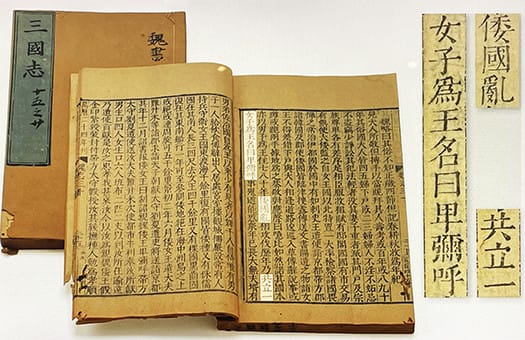
その上で推論を。魏志倭人伝の記述は『三国志』の一節で、
西晋の陳寿により西暦280年から297年に書かれたものというのが事実。
倭国についての訪問記録や口説などに基づいて記載されたとされている。
著者である陳寿が直接倭国を訪問したという事実はなさそうです。
なので、記載された内容の一々の証拠固めはされていないと考えるべき。
3世紀中期当時の日本の伝聞情報としてとらえるべきでしょう。
ひとつの理解コンパスとして、神武東征の年代を特定していくと
そこを起点として多くのことが推論可能かもしれない。
崇神天皇は10代天皇で奈良県の纏向に王宮を営んだことが確実視されている。
この崇神帝の在位推定年代(諸説あるけれど一説に西暦266-283年)が
この魏志倭人伝の記述対象年代に近似していると思われる。
当時の倭国について著者である陳寿が情報収集した年代にほぼ当たる。

纏向遺跡の所在地である現桜井市としては埋蔵文化財センターや、
「纏向学」研究センターなどを設置し「卑弥呼の里・国のはじまりの地」という
地域自治体を挙げての取り組み・研究を推進してきている。
わたしの過去ブログでも触れていまして、かねてから注目してきています。
3世紀の日本列島における中心的な祭政中心地があったとされている。
三輪山のふもとに位置して大神神社も市域。
一説で「卑弥呼の墳墓」といわれる最初期の前方後円墳「箸墓古墳」も近接。
想像イラスト(NHK番組での復元のようです)でわかるように
崇神帝が祭政の場としたと想像される建造物痕跡も発掘されている。
この建築群は居館というよりもアマテラス神と同居して
祭政一致の拠点としていた、とされているようです。
その後、崇神帝としては祭政の分離を意図し祭祀中心施設については後代、
伊勢に遷座させていったと言われている。

現地に行って見て、箸墓古墳・三輪山との地理的な連関性を考えると
この桜井市の取り組みには高い蓋然性があると思われるところ。
この時代以降、近隣の飛鳥に王宮が営まれ石舞台古墳などが多数造営される。
東アジア世界との外交的交流の推移なども考え合わせていくと
纏向が魏志倭人伝の伝える倭国の中心地域であった可能性が高いと思えます。
そう読み返してみると、魏志倭人伝がさらに身近に見えてくる・・・。


English version⬇

The Legend of Himiko, Wei-Shi-Wa-jin-Den: The 37,000-Year History of the Japanese Archipelago - 44
Approximation of the Mimukai site in Nara and the center of Japan in the Biographies of Wei and Himiko. Positive efforts in the local city of Sakurai. The probability seems high. ...

This is a blog series in response to the National Museum of Japanese History's eye-opening reorganization of its exhibits.
The biggest riddle in the exploration of ancient history, the biography of Wei Wei, is very modest.
Rather, it is introduced like a photograph with animated slide images.
I guess they had no way to deal with this point since there is no archaeological evidence for it.
I agree with such an attitude.
I would rather discuss the "process" of the establishment of kingship in the Nara Plain area.
I think there are much more empirical traces in this area.

I would like to make an inference based on this. The description of the Wei Shih Wahnamen is from a passage in the "Records of the Three Kingdoms".
The fact is that it was written by Chen Shou of the Western Jin Dynasty between 280 and 297 AD.
It is believed that the description was based on records of visits and oral accounts of the Japanese.
It does not seem to be true that the author, Chen Jue, visited Japan directly.
Therefore, it should be considered that the evidence for each and every one of the contents described has not been solidified.
It should be taken as hearsay information from Japan at the time of the mid-3rd century.
As one compass of understanding, if we identify the date of the Jinmu East Conquest
Many things may be deduced from that as a starting point.
It is certain that Emperor Sojin was the 10th emperor and built a royal palace in Mimamukai, Nara Prefecture.
The estimated date of reign of this Emperor Sojin (there are various theories, but one theory is that he reigned from 266 to 283 A.D.) is
The author of this book, "Wei-Shi-Wa-jin-Den," is a Japanese writer who wrote about the Japanese nation at that time.
This is about the time when the author, Chen Shou, collected information on the Japanese state at that time.

The current city of Sakurai, the location of the Miamukai site, has established a center for buried cultural properties and a research center for "Miamukai studies.
The city of Sakurai, where the site is located, has established a Center for Buried Cultural Properties and a research center for "Miamukai Studies.
The city of Sakurai, where the site is located, has established a center for buried cultural properties and a research center for "MATSUMAKI studies," and has been promoting local government-wide efforts and research to make the area "Himiko's village, the place where the nation began.
I have mentioned this in my past blogs and have been paying attention to it for a long time.
It is said that there was a central ritual center in the Japanese archipelago in the 3rd century.
Located at the foot of Mt. Miwa, the city is also home to the Ogami Shrine.
Chopstick Tomb Tumulus, the earliest forward-rear circular tomb, which is said to be "Himiko's Tomb," is also located nearby.
As you can see in the illustration (which seems to be a reconstruction from an NHK program)
As you can see in the imaginary illustration (which seems to be a reconstruction of the NHK program), traces of buildings that are imagined to have been used by the Emperor Sojin as a place for rituals and administration have been excavated.
This group of buildings was not a residence, but rather a base of unity in ritual and political affairs, cohabiting with the deity Amaterasu, as shown in the illustration.
The buildings are thought to have served as a base for ritual and political affairs.
Later, the emperor Takashi intended to separate ritual and politics, and moved the central ritual facility to Ise in later periods.
The central ritual facility was moved to Ise in later generations with the intention of separating rituals and administration.

When I visited the site and considered the geographical linkage with the tomb mound of Chopstick Tomb and Mt.
Sakurai City, there seems to be a high probability for this approach.
After this period, a royal palace was built in the neighboring Asuka, and many kofun tumuli were constructed, including the Ishibutai kofun tumulus.
When the transition of diplomatic exchanges with the East Asian world is also taken into consideration, it is possible to conclude that
It is highly possible that Muko-Mukai was the central region of Japan as described in Wei-Shi-Wa-jin-den.
Reading it back that way, the Wei-Shi-Wa-jin-den becomes even more familiar to us...

【関東中部東海 1-2世紀の世界 日本列島37,000年史-43】

2022-12-14 06:25:02 | 日記


国立歴史民俗博物館の1-2世紀の日本列島の状況解析パネル群。
北部九州が大陸・半島との文化の導入口である一方、
水田農耕の東進に伴って人口増加が各地で発生して在来の縄文文化と
あるいは対立したり混淆したりして独自の文化圏が形成された。
しかも北部九州はあまりにも国土全体からは西に偏りすぎているのと、
稲作の好適地域は日本列島各地に散在し、分散的な地域発展を見せていた。
きのうは「出雲王権」とおぼしき日本海地域を見たが、
本州島中部の関東中部東海という列島コア地域の状況です。

西方由来の文物の流入がこれら地域でも顕著とされている。
1-2世紀には鏡や銅鐸、鉄剣などの北部九州に端を発する各種金属製品が
これら東方世界にも浸透していった。
素材や形状は北部九州に由来しつつも東方独自の形が見えてきて、
文化の受容と自己主張の両面性が見えてくる、という解説。
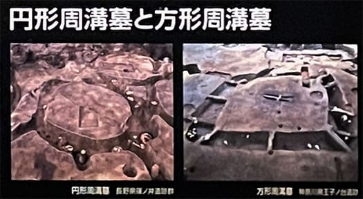
一方、墓制では円形周溝墓と方形周溝墓が営まれている。
東方日本では古来、周溝を持つ墓を営んできた。
周溝とは一種の「防衛施設」と考えるのが自然だと思うけれど、
板東という地域は、そのように荒々しい風土性を表現しているのか。
この時代からそうした地域性があって後の世に武士政権を生み出すのだろうか。
中部高地地域では円形周溝墓、東海〜関東では方形周溝墓という違い。
この周溝墓とは「共同墓域」とされているけれど、徐々に
西方からの金属製品やガラス玉などの副葬品を持った有力者の墓域が
このなかに顕在してくるようになる。
大量生産可能な稲作農業の浸透は、社会に格差を顕在化させたのだろう。
地図を詳細に見ていると、とくに関東地域での房総西部海岸、
その対岸地域としての相模地域に遺跡が集中していて、
たぶん古利根川の氾濫地域が広大に空白になっている様子が伝わる。
歴史年代になってくると「上総」は親王が守とされて
在地の最上位職は「介」とされる。古関東地域での房総の重要性がわかる。
そもそも「東海道」は三浦半島から渡海して上総に通っていたとされる。
また1-2世紀にはこの地域で赤く着色された土器が出現する。
列島各地の土器が色彩や装飾を失い簡素に実用性主体になっていくのに、
東方世界ではより強く「赤彩」を意識していたということ。
縄文土器から弥生土器に移行する大勢のなかで、どうも縄文的感受性が
一種の抵抗を見せてたようにも感じられるのだけれど、どうだろうか。

アジアの稲作農業にとって日本列島はある種、フロンティア。
後世でのヨーロッパ世界にとってのアメリカのような側面が強くあると思う。
文化的には色濃く受容しつつも、独立心は強く存在した。
朝鮮半島とはまた全然違う強い文化的求心力が働く地域だったように思える。


English version⬇

The World in the First and Second Centuries of the Kanto, Chubu, and Tokai Regions: The 37,000-Year History of the Japanese Archipelago - 42
The Japanese archipelago is the frontier of rice agriculture in Asia. It is thought that the dispersed existence of suitable land for cultivation fostered a strong culture of regional independence. The Japanese Islands

A group of panels analyzing the situation of the Japanese archipelago in the 1st and 2nd centuries at the National Museum of Japanese History.
While northern Kyushu was the entry point for the introduction of cultures from the continent and peninsulas
While northern Kyushu was a cultural gateway to the continent and peninsulas, the eastward expansion of rice paddy farming led to population growth in many areas, forming unique cultural areas that either conflicted with or intermingled with native Jomon culture.
The population growth in each region was accompanied by the eastward expansion of rice paddy agriculture, which resulted in the formation of unique cultural spheres that either conflicted or intermingled with native Jomon culture.
Moreover, Northern Kyushu is too far west of the country as a whole, and the best areas for rice cultivation are located in the Japanese archipelago.
The suitable areas for rice cultivation were scattered all over the Japanese archipelago, showing a decentralized regional development.
Yesterday, we saw the Sea of Japan region, which is considered to be the "Izumo Kingdom.
This is the situation in the core region of the archipelago, the Kanto Chubu Tokai region in the central part of Honshu Island.

The influx of cultural relics of western origin is also evident in these regions.
In the 1st and 2nd centuries, various metal products originating in northern Kyushu, such as mirrors, bronze bells, and iron swords
The materials and shapes of these objects originated in Northern Kyushu.
While the materials and shapes of these objects originated in northern Kyushu, they also had a unique form in the East.
This is a commentary on the dual nature of cultural acceptance and self-assertion.
On the other hand, in terms of the tomb system, circular and square periglottis tombs were constructed.
In Eastern Japan, tombs with ditches have been used since ancient times.
It is natural to think of peri-ditch tombs as a kind of "defense facility.
Does the region of Bando express such a rough endemic character?
Is it possible that such a regional character from this period would give rise to a warrior government in later generations?
The difference is that the Chubu Highland area has circular ditch tombs, while the Tokai to Kanto areas have square ditch tombs.
Although these periglottis tombs are considered to be "common grave sites," they are gradually being used as a place to store metal products, glass beads, and other items from the west.
The graves of influential people with metalware, glass beads, and other burial accessories from the west are gradually becoming apparent in this area.
The tombs are thought to be "communal grave sites.
The spread of mass-production rice agriculture must have brought about a disparity in society.
Looking at the map in detail, we can see that the western coast of Boso, especially in the Kanto region, and the Sagami region on the opposite coast of Boso.
The sites are concentrated in the Sagami area on the opposite coast of the Kanto region, and are probably the result of the flooding of the Ko-Tone River.
The map also shows that the flooded area of the Ko-Tone River is a large blank area.
In the historical period, "Kamihisa" was protected by the Oyashio, and the highest position in the locality was "Kuso".
The highest position in the locality is considered to be "Kozuke". This shows the importance of Boso in the old Kanto region.
It is said that the Tokaido Highway originally crossed the Miura Peninsula to reach Joso.
In the 1st and 2nd centuries, red-colored earthenware appeared in this region.
While pottery from other parts of the archipelago lost color and decoration and became simpler and more utilitarian.
While pottery from other parts of the archipelago lost color and decoration and became simpler and more utilitarian, the eastern world had a stronger awareness of "red coloring".
In the midst of the shift from Jomon to Yayoi earthenware, it seems as if Jomon sensibilities were showing a kind of resistance.
I wonder if this is because the Jomon sensibility was resisting the shift from Jomon earthenware to Yayoi earthenware.

The Japanese archipelago was a frontier for rice agriculture in Asia.
I think it has a strong aspect like America to the European world in later times.
While they were culturally accepted, they also had a strong sense of independence.
It seems to have been a region where a strong cultural centripetal force, completely different from that of the Korean peninsula, was at work.

【出雲王権か?1-2世紀日本海沿岸 日本列島37,000年史-42】

2022-12-13 05:51:58 | 日記


九州北部は日本列島のなかでは大陸・半島の文化流入の入口。
とはいえ、列島社会全体からすれば西のはずれに属する。
水田農耕がどんどんと東進していくことでその「適地」で人口増加が起こり
列島社会の中では多様な地域社会が形成されていった。
日本海側地域というのはそのなかでも有力な地域だったことで、
独自の地方勢力が力を持った存在になっていった。
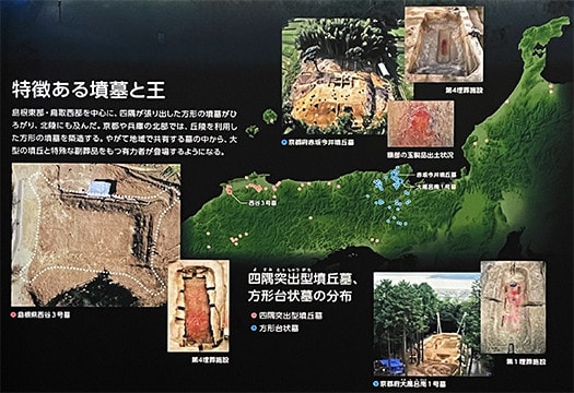
「特徴ある墳墓と王」という国立歴史民俗博物館パネル説明では以下の記述。
〜島根東部・鳥取西部を中心に四隅が張り出した形の墳墓が広がり
北陸にも及んだ。京都・兵庫北部では丘陵を利用した方形の墳墓を築造。
やがて共有の墓の中から大型の墳丘と特殊な副葬品をもつ有力者が登場する。〜
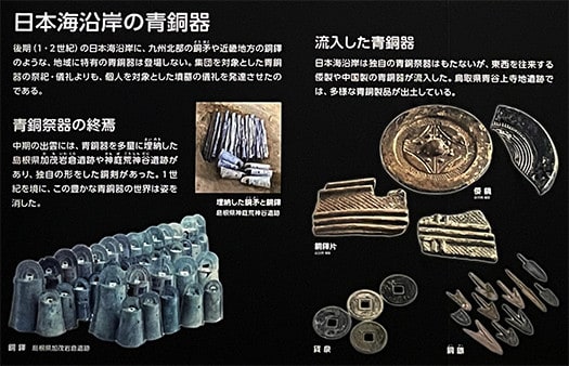
そして「日本海沿岸の青銅器」パネル説明は以下。
〜後期(1-2世紀)日本海地域に北部九州の銅矛や近畿地方の銅鐸のような
地域特有の青銅器は登場しない。集団を対象とした青銅器の祭祀・儀礼より
個人を対象とした墳墓の儀礼を発達させた。〜
そして「青銅記紀の終焉」では
〜中期出雲には青銅器を多量に埋納した荒神谷遺跡などがあり、独自の形をした
銅剣があった。1世紀を境にこの豊かな青銅器の世界は姿を消した。〜
やはり「出雲王権」の状況が見て取れるように思える。
日本海側を東進した人口増加がひとつの集団意思に統合されていた、
そういった仮説は十分に成立するように思われる。
それらの勢力が年に1月ほど神無月に出雲に集まって集会を開き、
独自の連合的「国家」を形作っていたものが出雲王権の実質と想像できる。


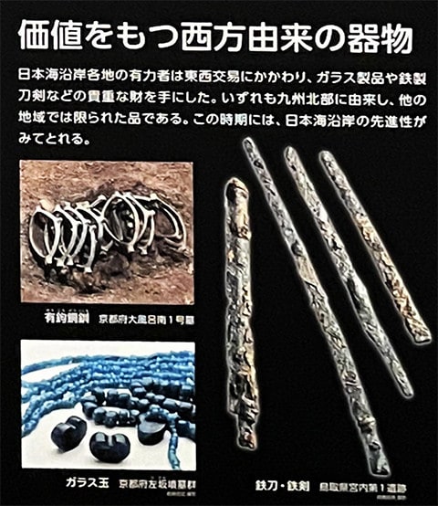
「価値を持つ西方由来の器物」では〜日本海側沿岸の有力者は東西交易に関わり
ガラス製品や鉄製刀剣などの貴重な財を入手した。いずれも北部九州に由来し
他地域では限られていた財。この時期の日本海沿岸の先進性がみてとれる。〜
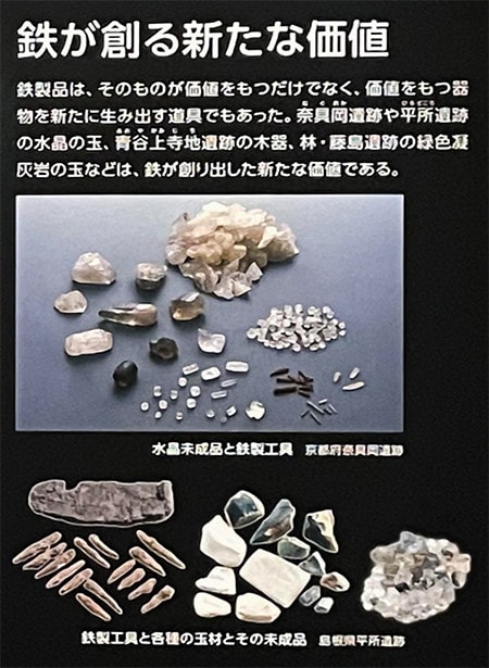
さらに「鉄が創る新たな価値」では〜鉄製品はそのものが持つ価値だけではなく
価値を持つあらたな器物を生み出す道具。水晶の玉、木器、緑色凝灰岩の玉、
などは鉄が創り出したあらたな物質価値だった。〜

列島社会での人口増加に伴って各地域に有力者が生まれて
それらの間で交易・交流が広がることで次第に「統一王権」という志向が
当然のように沸き立っていったことが容易に想像できる。
神武の一統は九州北部から瀬戸内海地域を進み、
岡山の吉備地域の有力層と強い同盟もしくは連携を得て
勇躍、大阪湾・難波地域に上陸を図ろうとしたと考えられる。
そういう東征が成功を収めて畿内地域に王権が樹立されたことで
出雲は「国譲り」して従ったという流れが自然だと思われますね。
このことは列島の支配構造・祭祀構造として環日本海型から
大和中心の集権型が勝利したという史実を表現しているのでしょうか。


English version⬇

The Izumo Kingdom: The Sea of Japan in the 1st and 2nd Centuries, 37,000 Years of Japanese Archipelago History-42
The eastward expansion of rice cultivation and agriculture created large population centers in various regions, starting in northern Kyushu. The Izumo Royalty Union was established in these areas. The Izumo Royalty Union was established in these areas.

Northern Kyushu is the gateway to the influx of continental and peninsular cultures in the Japanese archipelago.
Nevertheless, it belongs to the western edge of the archipelago's society as a whole.
As paddy field agriculture moved eastward, the population grew in the "suitable" areas, and diverse local communities were formed within the archipelago society.
This led to the formation of various regional societies in the archipelago.
The Sea of Japan region was one of the most influential regions in the archipelago.
The Sea of Japan region was one of the most powerful regions in the archipelago, and its own local power became a powerful entity.
The National Museum of Japanese History's panel "Characteristic Tombs and Kings" explains the following
〜The tombs with overhanging four corners spread mainly in eastern Shimane and western Tottori.
They also extended to the Hokuriku region. In Kyoto and northern Hyogo, square tombs were built on hillsides.
Eventually, among the shared tombs, influential figures with large burial mounds and special burial accessories appeared. ~.
And the "Bronze Artifacts from the Sea of Japan Coast" panel description is below.
〜In the late 2nd century, no region-specific bronze artifacts such as bronze pikes from northern Kyushu and bronze bells from the Kinki region appeared in the Sea of Japan region.
Bronze artifacts unique to the region do not appear in the Sea of Japan region. Bronze rituals and ceremonies are more important than group rituals and ceremonies.
The development of individual tomb rituals was more important than group rituals. ~.
And in "The End of the Bronze Chronicle
〜In the mid-1st century, Izumo had a large number of bronze artifacts buried at the Aragamitani site, including a uniquely shaped bronze sword.
After the 1st century, this rich world of bronze disappeared. ~.
The situation of the "Izumo Kingdom" can still be seen.
The population growth that moved eastward along the Sea of Japan was consolidated into a single collective will.
Such a hypothesis seems to be quite plausible.
These forces gathered in Izumo about one month a year during the kaminashi month, held a meeting, and formed their own federated "nation".
The Izumo Kingdom was in fact a unique federated "nation.

In the "valuable vessels of western origin," the leading figures of the coastal areas along the Sea of Japan were involved in trade between the east and west, and obtained valuable goods such as glassware and iron swords.
obtained valuable goods such as glassware and iron swords. All of them originated from northern Kyushu.
goods that were limited in other regions. The advanced nature of the Japan Sea coast during this period can be seen. 〜The "Iron and Steel" section of this report is a good example of this.
Furthermore, in "New Value Created by Iron," the author explains that iron products not only have value in their own right, but also
Iron products were not only valuable in their own right, but they were also tools for creating new vessels with value. Crystal balls, wooden vessels, green tuff balls
were new material values created by iron. 〜The first time iron was used in the world was in the 1930s.

As the population of the archipelago grew, powerful people emerged in each region.
As trade and exchange expanded among them, the desire for a "united kingdom" gradually
It is easy to imagine that the desire for a "unified kingship" gradually rose as a natural result of the expansion of trade and exchange among them.
The Jinmu line advanced from northern Kyushu to the Seto Inland Sea region.
The Jinmu line advanced from northern Kyushu to the Seto Inland Sea region, where they formed a strong alliance or partnership with the powerful people of the Kibi region in Okayama.
The Kamimu line is thought to have made a brave attempt to land in Osaka Bay and the Namba area.
With the success of such an expedition and the establishment of a royal authority in the Kinai region
It seems natural that Izumo "handed over the kingdom" and followed suit.
Does this represent the historical fact that the Yamato-centered centralization type prevailed over the Japan Sea Rim type as the ruling and ritual structure of the archipelago?
Does this represent the historical fact that the Yamato-centered centralized system triumphed over the Japan Sea Rim system as the ruling structure and ritual structure of the archipelago?

【1世紀の半島地域「三韓」 とは? 日本列島37,000年史-41】

2022-12-12 06:03:12 | 日記


古代の「国際関係」にとって非常に重要な半島地域。
日本列島社会にとってもっとも身近な地域として日本の王権の誕生に
大きな関わりを持っていたに違いないと思うけれど、
そうした関係論の解剖はあまり聞かない。
神武東征の時期が1世紀という説が強くなってくるとすれば
北部九州とこれらの地域との関係性は核心的だとも思える。
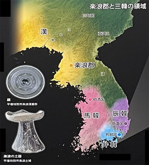
この時期の半島社会は、北に楽浪郡とその後その南方に置かれた帯方郡があり
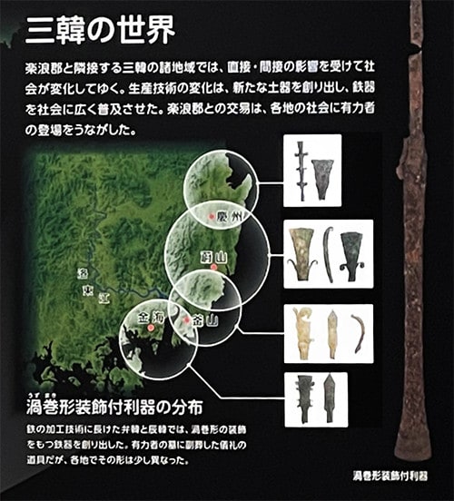
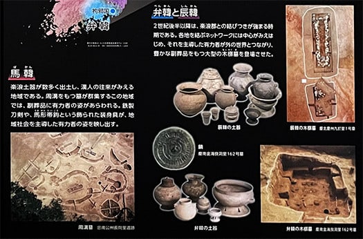
半島南部地域は三韓といわれる時代になっていた。
〜三韓とは1世紀から4世紀にかけての朝鮮半島南部に存在した集団とその地域。
108年朝鮮半島南部に漢の武帝が楽浪郡以下の四郡を置き郡県制の支配を及ぼし、
韓民族もその直接間接の支配を受けた。さらに3世紀には遼東太守公孫氏によって
帯方郡が設けられると帯方郡は三韓さらに海を隔てた倭を含んだ
東アジアのキーステーションの役割を果たした。
●韓民族の国家形成
313年に楽浪郡、翌年帯方郡が北方に急成長した高句麗によって滅ぼされた結果
帯方郡の間接的統治を受けていた韓民族に自立の動きが強まった。  
まず馬韓の50余国はその中の一つであった百済によって統合され、
辰韓の12余国は新羅によって統合された。
しかし弁韓の地は加羅など小国家分立が続き、
倭の大和政権も進出した。4世紀以降の朝鮮は三国時代といわれることになる。〜
大陸の独裁権力国家の消長の影響が大きく反映していた。

そういった国際情勢の中で神武は北部九州から東征し本州中部に王権を樹立。
このことは日本列島での「地政学」的には妥当性が高い動き。
しかし一方では半島−九州北部地域の方がはるかに先進地域。
白村江の海戦は西暦663年8月27日。これを沸騰点として
半島と列島の社会は非常に密接に関係して連動していたと思われる。
現代のわれわれは国家の存在を無意識の前提にして歴史を考えるけれど、
朝鮮半島の政治的緊張に対して海外派兵を決断するというのは
かなりの飛躍のある考え方だと思える。
それほどの半島南部社会との強い関係性があって決断したのだろう。
普通に考えれば、それはひとつの沸騰点であってむしろ日常的に
強い結びつきがあってその延長線上で派兵があったと考える方が自然。
また、白村江敗戦はちょうど戦後社会の大転換のような要素を
日本社会にもたらしたとも思える。
百済の臣民たちが大挙して列島に移動してきたことで王権が強化もされた。
祭政のレベルがそれを契機として一気に加速したことがわかる。


English version⬇

What was the "Three Hans" Peninsula Region in the 1st Century? The 37,000-Year History of the Japanese Archipelago - 41]
During the period of 600 years between the Shinmu Expedition and the Battle of Hakuchon River in 663, the unified government of Japan was born and had a strong relationship with the peninsular society. ...

The peninsula region is very important for "international relations" in ancient times.
It must have had a great deal to do with the birth of Japanese kingship as the region closest to the Japanese archipelago society.
I think it must have had a great deal to do with the birth of the Japanese kingship.
However, we do not hear much dissection of such a relationship.
If the theory of the first century is strengthened, the relationship between northern Kyushu and these regions is not so clear.
The relationship between northern Kyushu and these regions seems to be the core of the theory.
The society of the peninsula during this period consisted of Raknami-gun in the north and later Obihang-gun to the south of Raknami-gun.
The southern region of the peninsula was known as Sanhan.
〜The three Han are the groups and regions that existed in the southern part of the Korean Peninsula from the 1st to 4th centuries.
In 108, Emperor Wu of the Han Dynasty established four counties under Naknang-gun in the southern part of the Korean Peninsula and ruled it under the county and prefecture system.
The Han people were also ruled directly or indirectly by the Wudang. In the 3rd century, Gongsun, the governor of Liaodong
Bifang-gun was established by Gongsun, the governor of Liaodong in the 3rd century, and played the role of a key station in East Asia
The county played the role of a key station in East Asia, including the three Koreas and Japan, which was located across the sea.
Formation of the Han Nation
After the destruction of Yeoknam-gun in 313 and Obihang-gun the following year by the rapidly growing Goguryeo Dynasty in the north
The indirect rule of Bihang-gun led to a growing movement toward self-reliance among the Han people.  
First, the 50-odd states of Mahan were united by Baekje, which was one of the 50-odd states of Mahan.
The 12 countries of the Jinhan region were united by Silla. However, the division of small states continued in Benhan, such as Kara, and the Yamato regime of Japan also moved in.
From the 4th century onward, Korea was known as the Three Kingdoms Period. 〜The fourth century onward, Joseon became known as the Three Kingdoms Period.
The influence of the dissipation of dictatorial powers on the continent was greatly reflected in the Joseon Dynasty.

In such an international situation, Jinmu conquered the east from northern Kyushu and established a royal authority in the central part of Honshu.
This was a highly appropriate move in terms of "geopolitics" in the Japanese archipelago.
On the other hand, however, the Peninsula - northern Kyushu region is a much more advanced region.
The Battle of Hakumura-jiang was on August 27, 663 AD. This was the boiling point.
Peninsular and archipelagic societies seem to have been very closely related and interlocked.
Today, we think of history based on the unconscious assumption of the existence of a nation.
But the decision to deploy troops overseas in response to political tensions on the Korean peninsula seems to me to be a considerable leap of faith.
It is quite a leap of faith.
The decision must have been based on such a strong relationship with the society in the southern part of the peninsula.
Normally, this would be a boiling point, but it is more likely that the decision was made because of the strong ties that exist between the two Koreas on a day-to-day basis.
It is more natural to think that there were strong ties between the two countries on a daily basis, and that the deployment of troops was an extension of those ties.
The defeat at the Hakuchon River also seems to have brought about a major social change in postwar Japan.
The defeat at Baekchonjiang brought about a major shift in Japanese society in the postwar period.
The large number of Baekje subjects who moved to the archipelago also strengthened the royal authority.
The level of ritual government was accelerated by this event.