


さてきのうまでで浦和の古民家園シリーズを終えました。
で、関東の古代の姿を再確認していくと、利根川の東遷という巨大自然改造が江戸時代初期に行われて、その結果として首都地域・江戸東京の地域的安定性が高まった様子がわかってきた。
先日中国では台風の被害で首都・北京での大洪水ぶりが報道されていました。北京からのニュース映像では、コンクリート製の橋が崩壊したりしていました。ことしの夏の異常と言われる暑さといい気候の凶暴化ということも言われていますが、さてどうなのでしょうか?
日本でもあのような洪水被害が家康による大土木工事以前には日常的にあったと推測できます。利根川東遷という公共事業の有効性が、その後の首都東京の発展の基礎だったことを考えれば、先人の労苦の重みを知らされる。家康という存在は、戦国の覇者という側面も大きいけれど、治山治水という政治の要諦における果断な判断力、政治力の凄さを知らされる思いがします。「どうする家康」で、今後、そういうドラマチックではない側面にどこまで迫れるでしょうか?武将としての役割を持って仕えた本多忠勝が晩年、家康の政治中心姿勢に「平八は(怒りで)腹が腐って果てました、と伝えろ」と嘆いた説話がある。
このあたり興味を持っていますが、さて「どうする家康」はどうする?
で、話は戻って、関東最大の暴れ川にして関東の地域開発の障害になっていた利根川。家康が東遷させて治水の実効性を高め領国の経済安定を実現させる前からの太平洋に面した地域、霞ヶ浦〜香取の海の付近に鎮座する東国三社、鹿島神宮・息栖神社・香取神宮の周辺地域に強く興味が向かった。
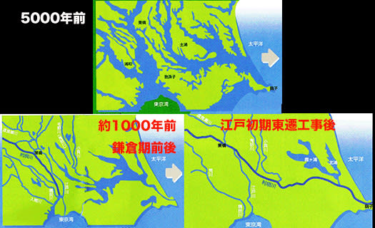
ちょうど2番目の地図では、関東平野地域の地形変化ぶりを表現していますが、利根川を東遷させた水路の最終地が、これらの神が鎮座する地域に相当するのですね。利根川東遷でこの地域に流路変更させたこととの歴史的関係性は? それは偶然なのか?
関東平野を真横に貫く国土改造計画であったことがよくわかる。家康は戦国の武将であった以上に、田中角栄の数十倍の「日本列島改造」者であったことがわかるのですね。
北海道ではここまでの自然改造の必要性はなかったけれど、代わりに寒冷気候対応でのフロンティア開拓移住、住宅の高断熱高気密化という住宅技術開発が必須化されて、利根川東遷とも比肩できる「日本人住意識改造」を進めたとも思える。
北海道人としてはこんな思いから無縁の先人痕跡とも思えない部分があって、ときおりこの東国三社地域への歴史経緯掘り起こし探究をしてきています。
北海道からはかなり遠い地域だけれど、成田空港便が便利になったことで比較的に身近になっても来ている。そんなことから、利根川東遷の最終経路流域を探ってみたい。
English version⬇
From the traces of the eastward shift of the Tone River to Kashima Jingu Shrine and the three shrines in the eastern part of Japan
Ieyasu was a warlord, but more than that, he was a remodeler of the Japanese archipelago dozens of times greater than Kakuei Tanaka. His frontier spirit can be traced back to the development of Hokkaido. Hokkaido
Well, we have finished the series of the old private house garden in Urawa until yesterday.
In reconfirming the ancient state of the Kanto region, I have come to understand how a huge natural transformation called the eastward shift of the Tone River took place in the early Edo period (1603-1868), which resulted in the increased regional stability of the capital region, Edo Tokyo.
The other day in China, the typhoon damage caused by the typhoon was reported as a major flooding in the capital city of Beijing. News footage from Beijing showed concrete bridges collapsing. The summer heat this year is said to be abnormal and the climate is said to be getting more violent, but what do you think?
It can be inferred that flood damage like that was common in Japan before Ieyasu's massive civil engineering works. Considering that the effectiveness of the public works project of moving the Tone River eastward was the basis for the subsequent development of the capital city of Tokyo, we are informed of the weight of our predecessors' labor and hardship. Ieyasu was not only the supreme ruler of the Warring States period, but he was also a man of decisive judgment and political power in the key political issue of flood control. I wonder how much of this less dramatic side of Ieyasu will be explored in "What to Do About Ieyasu" in the future? There is a story that Honda Tadakatsu, who served as a military commander, lamented Ieyasu's politically-centered stance in his later years, saying, "Tell him that Heihachi ended up with a rotten stomach (due to anger).
I am interested in this area. Now, what about "What to do, Ieyasu?
So, back to the Tone River, which was the largest rampaging river in the Kanto region and an obstacle to regional development in the Kanto region. I was strongly interested in the area facing the Pacific Ocean before Ieyasu moved it eastward to increase the effectiveness of flood control and achieve economic stability in his domain, and the area around the three shrines of the East, Kashima Shrine, Katori Shrine, and Katori Shrine, which are located near the sea from Kasumigaura to Katori.
Just the second map shows the topographical changes in the Kanto Plain area, and the final location of the waterway that moved the Tone River eastward corresponds to the area where these deities are located. What is the historical relationship between the Tone River's eastward shift and the fact that the flow path was changed in this area? Is it a coincidence?
It is clear that this was a national land reform plan that went right across the Kanto Plain. You can see that Ieyasu was more than a warlord, he was a "remodeler of the Japanese archipelago" dozens of times more than Kakuei Tanaka.
In Hokkaido, there was no need to remodel the natural environment to this extent, but instead, frontier settlements in response to the cold climate and the development of housing technology to make houses highly insulated and airtight were essential, which can be compared to the Tone River Eastward Transition.
As a Hokkaido native, I have sometimes been exploring the history of the three shrines in the eastern part of the country, because I cannot think of them as traces of ancestors unrelated to me.
Although the area is quite far from Hokkaido, it has become relatively close to us thanks to the convenience of flights from Narita Airport. In light of this, I would like to explore the final route basin of the Tone River's eastward transition.


※コメント投稿者のブログIDはブログ作成者のみに通知されます