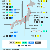
2015-07-23 23:43:32 jtwc
合同台風警報センター(ごうどうたいふうけいほうセンター、JTWC; Joint Typhoon Warning Center)は、アメリカ海軍とアメリカ空軍がハワイ州真珠湾海軍基地の海軍太平洋気象海洋センターに共同で設置した機関である。アメリカ国防総省と合衆国およびミクロネシア地域住民の利益に供する為、北西太平洋地域、南太平洋地域、インド洋地域で発生する台風および熱帯低気圧について監視し、警報を発する任務を負う。
アメリカ国防総省に所属するすべての部署に情報を提供し、世界各国と連携して船舶および航空機の安全な航行を保障するために活動している[1]。
| 合同台風警報センター | |
|---|---|
| Joint Typhoon Warning Center | |
 |
|
| 組織の概要 | |
| 設立年月日 | 1959年5月1日 |
| 本部所在地 | |
| 人員 | 31人 |
| 上位組織 | アメリカ海軍 アメリカ空軍 |
| ウェブサイト | |
be careful) timetable account is Coordinate Universal Time (for transcription in the text, Z), so when correcting it in Japan time,+ please do for 9 hours.
注意)時刻表記が協定世界時(文中表記はZ)となっているので、日本時間に直す際は+9時間して下さい。
2015-07-23 23:43:32 Tenki.jp.
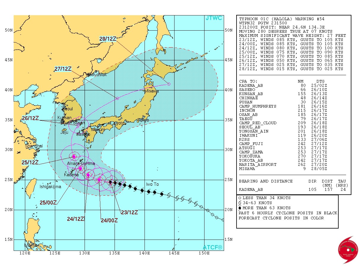
The course where number 12 of typhoon is latest and influence to Japan
July 23, 2015 16:10
The fear by which number 12 of typhoon is approach to Okinawa-honto on Saturday. After that the expectation which changes course to northern lay. The latest material, and, influence to Japan, they're diligent with oh, oh, it was done.
Cloud imagery of number 8 of sunflower
Cloud imagery of number 8 of sunflower
Course of a typhoon It's in western lay more than yesterday's expectation.
I'm advancing the south of Japan towards western lay current as of number 12 of typhoon.
It's after that, course was changing to the expectation more developed in western lay until yesterday.
Number 12 of typhoon is quite close to Daitojima area on Friday, and there is a fear that I approach in Okinawa-honto area on Saturday.
After that when I advance the center of the forecast yen, one after Monday advances the western sea in Kyushu on Sunday, and is the expectation towards which I advance the Sea of Japan.
The forecast yen is still big, but when it's compared so far, the width of the expectation is being also small.
Course expectation of a typhoon
Course expectation of a typhoon
Influence to all part
[Western Japan]
A wind is also strengthened at the Kyushu south on Saturday, and there is a possibility that a wind is strengthened at the Kyushu north and a Western part of Honshu to Sunday-Monday.
The air by which the typhoon circumference became moist flows, and it's rain locally, I'd strengthen.
The sea becomes expensive with the welter, so please be careful.
There is also more fear which becomes the rough weather in the wide area by course, so attention will be also necessary to the latest typhoon information from now on.
[Eastern Japan]
A possibility that I undergo direct influence of a typhoon was becoming short as of now in Kanto area and Tokai.
A typhoon would be the aerial influence by which carried tropics-upbringing became moist warmly and be the heat boiled again.
It's the expectation which will be a heat wave day here and there after Saturday, and every day, the highest temperature is also 35 times of expectation from Saturday to Monday Tokyo.
They seem to increase in more unpleasant feelings because it's also humid.
Please be careful about heat exhaustion.
Further, we still have some latitude in course expectation of a typhoon.
Please be also careful about the latest typhoon information and weather information from now on.
2015-07-23 23:43:32 Tenki.jp.
台風12号 最新の進路と日本への影響
2015年7月23日 16時10分

ひまわり8号の雲画像
台風の進路 昨日の予想より西よりに
その後の進路は、昨日までより、西よりに進む予想に変わってきました。
台風12号は金曜日には大東島地方へかなり接近、土曜日には沖縄本島地方に接近する恐れがあります。
その後、予報円の中心を進むと、日曜日には九州の西の海上を進み、月曜日以降は日本海を進む予想です。
まだ、予報円は大きいですが、これまでに比べると予想の幅も小さくなってきています。

台風の進路予想
各地への影響
【西日本】
土曜日は九州南部でも風が強まり、日曜日~月曜日にかけては九州北部や中国地方などでも風の強まる可能性があります。
また、台風周辺の湿った空気が流れ込み、局地的に雨脚の強まることもあるでしょう。
海上はうねりを伴い高くなりますのでご注意下さい。
進路によっては、さらに広い範囲で荒れた天気となる恐れもありますので、今後も最新の台風情報に注意が必要です。
【東日本】
関東や東海は今の時点では、台風の直接的な影響を受ける可能性は低くなってきました。
ただ、台風が運ぶ熱帯育ちの暖かく湿った空気の影響で、再び、うだるような暑さとなるでしょう。
土曜日以降は所々で猛暑日となる予想で、東京も土曜日から月曜日にかけて連日、最高気温は35度の予想です。
湿気も多いため、いっそう不快感が増しそうです。
熱中症にご注意下さい。
なお、台風の進路予想にはまだ幅があります。
今後も最新の台風情報、気象情報にご注意下さい。