


February 22, 2014 in the whole world (Saturday) for the first time in the International Open Data Day,
February 16, 2013 (Sun) 10:00 to 17:00 at Kyoto Research Park Building No. 4,
International Open Data Day 2014 in Kyoto pre-event was held.
https://www.facebook.com/events/1416743565233390/
http://peatix.com/event/28861/
The International Open Data Day 2014 in Kyoto pre-event,
Taking advantage of Kyoto feature full of historical and cultural assets,
Create an open data with everyone event "town walk open data Son"
("Wikipedia Town" + "OpenStreetMap (OSM) mapping party" + "open data full map Walk") we gave a.
In recent years, there has been an increasing expectation of open data release of information that government has, you are showing signs of obtaining the open data published in government. Of course, even myself, but in the direction we believe that it should proceed future,
"I open data, really from the government, I wonder just what you get?"
and "not just administrative Kurekure theory, and than can be something even our own?"
Because is was the starting point for planning this event.
To everyone is one also "wikipedia" is also of open data that was seen, "OpenStreetMap (OSM)" also is a map of open data.
In May 2013 in Yokohama, the Yokohama to Wikipedia Town "wikipedia Town Yokohama"
http://www.solabo.net/wiki0525/
have been made.
In addition, in the Futakotamagawa of Tokyo, is trying to "Wikipedia Town" and "" is a combination of OpenStreetMap (OSM) mapping party "," Futakotamagawa to Wikipedia Town! "
http://creative-city.jp/news/2013/0618_093330.html
have been made.
So, this time, also in Kyoto, "and not to expect only to government open data, while learning the history and culture of the region, everyone Let's do the events that try to make open data!" Because is, this event of was the gist.
?
**************************************************
International Open Data Day 2014 in Kyoto Pre-Event
Date: February 16, 2014 (Sun) 10:00 to 18:00
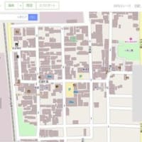
Location: Kyoto Research Park Building No. 4 2F Room 2B
http://www.krp.co.jp/kaigi/map/index.html
Address: Shimogyo-ku, Kyoto Chudojiawata cho, 90-94
http://www.krp.co.jp/access/index.html
Participants: citizens, local government officials, business officials, universities and educational institutions officials
Capacity: about 50 people
Admission: Free
Organizer: Kyoto open data practice sessions, GoogleDeveloperGroup Kyoto, NPO corporation Linked Open Data Initiative, Ltd. ATR Creative
http://linkedopendata.jp/
Supported by: Ministry of Internal Affairs and Communications Kinki Bureau of Telecommunications, open data distribution Promotion Consortium, Kyoto Research Park Co., Ltd.
**************************************************
program
10:00 to 10:10 Opening
10:10 to 10:25 Co., Ltd. from Kyoto Research Park's, Greetings
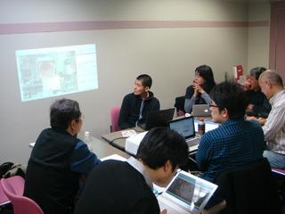
10:25 to 10:45 for the "Google Maps API" (GoogleDeveloperGroup than Kyoto's)
10:45 to 11:05 for the "open data full map Walk" (from the Corporation ATR Creative's)
11: 05 ~ 11: how to proceed with the 25, "OpenStreetMap (OSM) mapping party"
11:25 to 11:45 on how to proceed in the "wikipedia"
11:45 to 11:55 on how to proceed in the "wikipedia Town"
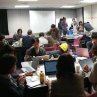
11:55 to 12:15 grouping
12:15 to 13:30 noon break
13:30 to 15:00 in teams, town some Ki local survey Location: ShimaGen (Shimabara)
15:00 to 17:00 in teams, and open data creation work at the venue
17:00 to 17:30 each team results announcement -
**************************************************
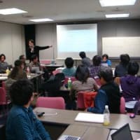
From people in the morning of each field, for the point to be put on how to proceed and care, I received lecture, was your study.

A description of the mapping and copyright of OpenStreetMap (OSM)
?

A description of the wikipedia
?

There was a description of the data of the Kyoto specification view of the plan to use open data full map walk.
?

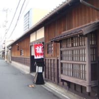
After a description of the red-light district "ShimaGen (Shimabara)", which is the Kyoto Research Park near the historical and cultural heritage of the venue,
?

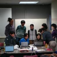
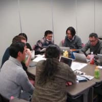
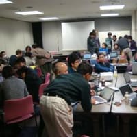
Each participant, we were divided into four groups to perform a field survey open data Son work.
?
In the afternoon, we did a field survey of the red-light district "ShimaGen (Shimabara)".


In the field, the Ya Sakurai's "meeting to consider the Kyoto Tourism and Culture", as he is active in the region

To Komai's "Shimabara Friendship Club", we have to your description of ShimaGen.
At Kadoya

At the wheel 違屋

At Daimon

At Mibu-dera

At Shinsengumi Mibu military station Yagi House

At Shinsengumi Mibu military station old Maekawa House
?
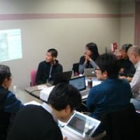
After the field survey, towards the veteran wikipedian who participated, from the direction of veteran OpenStreet mapper, while I will teach how to direct proceeds gait work, we gave a "wikipedia" create work and OpenStreetMap create work with everyone.

For Wikipedia created and edited, it is necessary to describe the objective content, on which it was available, based on the field survey, there is a need to continue to describe. This time, Kyoto library, in our cooperation to members of the museum relationship, advance the literature materials on ShimaGen regional and Mibu area we have available over the documentation. Did on reading and understanding these materials, we work to continue to digitize so as not to circle copy.

Only there is no open data creation work time about two hours, everyone, been found that way, exactly now full-scale work! In a place called, it has mercilessly trees end time.

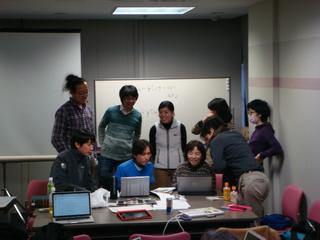
It was about two hours of work time, but was able to raise the each group achievements.
?
Each group results
1. Outcome of Kadoya group
https://ja.wikipedia.org/wiki/%E8%A7%92%E5%B1%8B
change history
https: // ja. wikipedia.org/w/index.php?title=%E8%A7%92%E5%B1%8B&action=history
2. Outcome of wheel 違屋 group
https: //ja.wikipedia. org / wiki /% E8% BC% AA% E9% 81% 95% E5% B1% 8B
change history
https://ja.wikipedia.org/w/index.php?title=%E8%BC%AA%E9%81%95%E5%B1%8B&action=history
?
3. Outcome of Daimon group
Wiki Create a new item
https: //ja.wikipedia.org/wiki/%E5%B6%8B%E5%8E%9F%E5%A4%A7%E9%96%80
change history
https://ja.wikipedia.org/w/index.php?title=%E5%B6%8B%E5%8E%9F%E5%A4%A7%E9%96%80&action=history
?
4. Outcome of Mibu group
https://ja.wikipedia.org/wiki/%E5%A3%AC%E7%94%9F_ (% E4% BA% AC% E9% 83% BD% E5% B8% 82)
change history
https://ja.wikipedia.org/w/index.php?title=%E5%A3%AC%E7%94%9F_ (% E4% BA % AC% E9% 83% BD% E5% B8% 82) & action = history
?

OpenStreetMap around Shimabara after work
?
OpenStreetMap that has been created and edited You can see from the following link.
http://www.openstreetmap.org/#map=18/34.99261/135.74470
?
?

Finally, we gave each group the results announcement.


?
Everyone, to come know the way, just now full-scale work! When in place, came the end time that is, was very disappointing.
And a lecture in the morning, by a field survey in the afternoon, there was impossible to schedule and that the open data Son work.
Towards the International open data Day of February 22 (Saturday) in Kyoto, I was keenly aware that it is necessary to adjust the schedule.
?
Put serious about, in order to complete the "wikipedia" Creating and editing or "OpenStreetMap" creation and editing of the constant region, it does not end until it completed! You must just be the "open data" Son "".
That's what, I think is not necessary "training camp of making open data editing Become a about a week canned" = "open data Son camp!" Is.
When it was this story venue, even those participants in the venue that he nodded, and was he a lot? ? Because, by all means! ? Going forward, we would like to consider! ?
?
But it was a short time, for anyone that is the first time to create and edit the open data, "wikipedia" created and edited and "OpenStreetMap" the creation and editing work, that get to tell proceeds pace towards to each veteran , I think not did I get a very valuable experience.
Contact one of the person who had you the results announcement, and "It was easier than I thought. Also I want to do little by little when some of yourself in time" of woven by saying and it was impressive.
By increasing the number of such opportunities, the more people have, the local information of the analog which has been stacked in so far unbroken line and each region, by which the public as an open data digitized little by little, - the distribution of regional information secondary use is made, re-discovery of the region, also opens up the possibility to be connected to activation, it was one day felt that there no longer one of the significance of open data.
?
But it will be the last,
"Wikipedia" create and edit working your veteran Wikipedian that had you tell everyone.
"OpenStreetMap" your veteran mapper that had you tell me the creation and editing work.
For Wikipedia create and edit, Kyoto library who have served over the documentation, your museum officials.
Sakurai's had you for your description of ShimaGen "meeting to consider the Kyoto Tourism and Culture", Komai's "Shimabara Friendship Club".
Your sponsorship Whats Ministry of Internal Affairs and Communications Kinki Bureau of Telecommunications, Mr. open data distribution Promotion Consortium's, Kyoto Research Park Corporation's.
Thank you.

本文にある「島原大門」は「しまばらだいもん(Daimon)」ではなく「しまばらおおもん(O-mon)」です。
名称はちゃんと調べて伝承しないといけないでしょう。
You say "Shimabara Daimon" is "Shimabara O-mon".
Please correct if there is any difference in the data.
You must check the right name properly.